
the Creative Commons Attribution 4.0 License.
the Creative Commons Attribution 4.0 License.
 | 16 Oct 2025
Satellite Data Rendered Irrigation using Penman-Monteith and SEBAL – sDRIPS for Surface Water Irrigation Optimization
Abstract. This study proposes a satellite remote sensing-based water-provider-centric irrigation advisory system designed to manage surface water resources and allocate water efficiently to areas in need, thereby promoting sustainable irrigation practices in the context of a changing climate. The system utilizes satellite remote sensing based SEBAL (Surface Energy Balance Algorithm for Land) and Penman-Monteith evapotranspiration models to estimate crop water use. By integrating the responses from the previous irrigation cycle, current precipitation, forecasted precipitation, and evapotranspiration-based water needs, the framework calculates the net water requirements for command areas within irrigation canal networks. Operating on a weekly basis, the system generates advisories that enable the irrigation water provider to make informed, science-based decisions about water allocation. These advisories quantify the net water requirement, giving water providers the flexibility to dispatch water to areas of higher need based on their on-ground judgment. Additionally, the proposed framework can simulate future cropping patterns by assuming potential policy changes or net reduction in water supply in the main canal due to climate change or increased transboundary withdrawal. The advisory system is co-developed and implemented with the irrigation management agency called Bangladesh Water Development Board on the Teesta River Irrigation System located in Northern Bangladesh. The study demonstrates its effectiveness when compared against actual water supplied for irrigation. However, the application of sDRIPS is not limited to Bangladesh, as it is scalable to other regions with similar water management challenges for agriculture.
-
Notice on discussion status
The requested preprint has a corresponding peer-reviewed final revised paper. You are encouraged to refer to the final revised version.
-
Preprint
(2551 KB)
-
Supplement
(579 KB)
-
The requested preprint has a corresponding peer-reviewed final revised paper. You are encouraged to refer to the final revised version.
- Preprint
(2551 KB) - Metadata XML
-
Supplement
(579 KB) - BibTeX
- EndNote
- Final revised paper


Journal article(s) based on this preprint
Interactive discussion
Status: closed
-
RC1: 'Comment on egusphere-2025-4574', Anonymous Referee #1, 08 Dec 2025
- AC1: 'Reply on RC1', Shahzaib Khan, 11 Jan 2026
-
RC2: 'Comment on egusphere-2025-4574', Anonymous Referee #2, 22 Dec 2025
The authors have developed a satellite remote sensing-based method of estimating irrigation requirements at the field application scale – utilizing the Penman-Monteith and the SEBAL methods of evapotranspiration – and the sDRIPS approach to provide irrigation advisory for surface water resources allocation.
The manuscript is very well-written, with a thorough literature review, visualizations, and rationale of the applications approach. The mathematical equations and details of the step-by-step approach for irrigation requirements calculation is appreciated. The results with figures and the detailed discussion on the limitations are noted as well.
Several questions and comments for clarification:
- Lines 84-86: For the ‘How much’ of irrigation – isn’t the unit depth of irrigation (L) a better estimate for irrigation requirements (also widely used metric across the world)? From the water depth required, the water volume (L3) and the flow rate (L3/T) can easily be calculated based on field size and hydraulic infrastructure?
- Lines 360, 366: In Equations 5 and 6, how is ‘Field Capacity’ estimated? It is unclear.
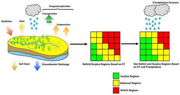
- The visualizations of Figure 2 are excellent. The gridded ‘Surplus/Balanced/Deficit Regions’ approach are not, however, found later. Is Figure 4 a modified version of this approach? Are the gridded calculations aggregated at the field scale in later figures?
Citation: https://doi.org/10.5194/egusphere-2025-4574-RC2 - AC2: 'Reply on RC2', Shahzaib Khan, 11 Jan 2026
Peer review completion


Interactive discussion
Status: closed
-
RC1: 'Comment on egusphere-2025-4574', Anonymous Referee #1, 08 Dec 2025
The authors propose a framework for providing spatially distributed irrigation advices by leveraging Earth Observation, which is for sure a timely topic in the broader context of water resources management. However, three main issues critically affect the manuscript quality:
1. Implementation over just few days/weeks. This is a gap, at least an entire irrigation season should be covered to prove the method robustness. Fig. 8 is where a 3-month period is shown for the first time, but it is not clear whether it is a whole season or not. Since water allocation managers often have control on seasonal volumes, I believe that comparing seasonal-aggregated advices with availabilities is meaningful.
2. Validation: even though I appreciate authors’ efforts in this sense, it is not carried out in a rigorous way. It targets other areas (with different climate conditions) and likely different vegetation/crop patterns. In addition, SEBAL, which is the basis for ET calculation for sDRIPS, is involved in OpenET also. If a direct validation is not possible, authors should just look for and mention previous studies validating SEBAL in several climate context (possibly involving the one of interest) to support the method reliability.
3. Manuscript organization: the paper is too long and a bit confused in several parts.
Please find additional comments as follows:
L 90-94: some initiatives to fill this gap are under development, e.g., ESA (European Space Agency) WorldCereal (https://esa-worldcereal.org/en)
L 138-147: it concerns data used, should not be in the introduction
L 149-186: should be sharply shortened
L 198-204: keep units’ consistency and use the International System
Eq 2: here is an underlying assumption that evaporation from bare soil is negligible, the Kc you are calculating is basically Kcb. If so, please detail on this. A question on top of this. At this stage soil moisture is already needed to compute Ks, isn’t it?
L 334-336: sounds like results
Fig 4: it seems that some coarse resolution input drives this result
Soil Moisture: how was it calculated? This is an important omission. In addition, it is expressed as water height (mm). This implies that the reference volume is known. Soil layer is fixed at 100 mm (as seen by Figures), what about the porosity?
Eq 6: maybe you could directly mention this one instead of eq 5 – which is a specific case of eq 6
Fig 5: How did you handle soil moisture estimate at the command area level?
Eq 7: even though it is explained afterwards, this equation could be misleading, as rainfall reduces net water requirement
L 399-400: this should be proved
L 474-484: not needed
L 495: more details on this in the “Data” Section?
Fig 9 and 10: On top of the criticism to the significance of validation, description here is qualitative only, as no metrics are providedCitation: https://doi.org/10.5194/egusphere-2025-4574-RC1 - AC1: 'Reply on RC1', Shahzaib Khan, 11 Jan 2026
-
RC2: 'Comment on egusphere-2025-4574', Anonymous Referee #2, 22 Dec 2025
The authors have developed a satellite remote sensing-based method of estimating irrigation requirements at the field application scale – utilizing the Penman-Monteith and the SEBAL methods of evapotranspiration – and the sDRIPS approach to provide irrigation advisory for surface water resources allocation.
The manuscript is very well-written, with a thorough literature review, visualizations, and rationale of the applications approach. The mathematical equations and details of the step-by-step approach for irrigation requirements calculation is appreciated. The results with figures and the detailed discussion on the limitations are noted as well.
Several questions and comments for clarification:
- Lines 84-86: For the ‘How much’ of irrigation – isn’t the unit depth of irrigation (L) a better estimate for irrigation requirements (also widely used metric across the world)? From the water depth required, the water volume (L3) and the flow rate (L3/T) can easily be calculated based on field size and hydraulic infrastructure?
- Lines 360, 366: In Equations 5 and 6, how is ‘Field Capacity’ estimated? It is unclear.
- The visualizations of Figure 2 are excellent. The gridded ‘Surplus/Balanced/Deficit Regions’ approach are not, however, found later. Is Figure 4 a modified version of this approach? Are the gridded calculations aggregated at the field scale in later figures?
Citation: https://doi.org/10.5194/egusphere-2025-4574-RC2 - AC2: 'Reply on RC2', Shahzaib Khan, 11 Jan 2026
Peer review completion
Journal article(s) based on this preprint
Viewed
| HTML | XML | Total | Supplement | BibTeX | EndNote | |
|---|---|---|---|---|---|---|
| 2,966 | 1,192 | 180 | 4,338 | 322 | 138 | 157 |
- HTML: 2,966
- PDF: 1,192
- XML: 180
- Total: 4,338
- Supplement: 322
- BibTeX: 138
- EndNote: 157
Viewed (geographical distribution)
| Country | # | Views | % |
|---|
| Total: | 0 |
| HTML: | 0 |
| PDF: | 0 |
| XML: | 0 |
- 1

Faisal Hossain
Khairul Islam
Mahfuz Ahamed
The requested preprint has a corresponding peer-reviewed final revised paper. You are encouraged to refer to the final revised version.
- Preprint
(2551 KB) - Metadata XML
-
Supplement
(579 KB) - BibTeX
- EndNote
- Final revised paper
The authors propose a framework for providing spatially distributed irrigation advices by leveraging Earth Observation, which is for sure a timely topic in the broader context of water resources management. However, three main issues critically affect the manuscript quality:
1. Implementation over just few days/weeks. This is a gap, at least an entire irrigation season should be covered to prove the method robustness. Fig. 8 is where a 3-month period is shown for the first time, but it is not clear whether it is a whole season or not. Since water allocation managers often have control on seasonal volumes, I believe that comparing seasonal-aggregated advices with availabilities is meaningful.
2. Validation: even though I appreciate authors’ efforts in this sense, it is not carried out in a rigorous way. It targets other areas (with different climate conditions) and likely different vegetation/crop patterns. In addition, SEBAL, which is the basis for ET calculation for sDRIPS, is involved in OpenET also. If a direct validation is not possible, authors should just look for and mention previous studies validating SEBAL in several climate context (possibly involving the one of interest) to support the method reliability.
3. Manuscript organization: the paper is too long and a bit confused in several parts.
Please find additional comments as follows:
L 90-94: some initiatives to fill this gap are under development, e.g., ESA (European Space Agency) WorldCereal (https://esa-worldcereal.org/en)
L 138-147: it concerns data used, should not be in the introduction
L 149-186: should be sharply shortened
L 198-204: keep units’ consistency and use the International System
Eq 2: here is an underlying assumption that evaporation from bare soil is negligible, the Kc you are calculating is basically Kcb. If so, please detail on this. A question on top of this. At this stage soil moisture is already needed to compute Ks, isn’t it?
L 334-336: sounds like results
Fig 4: it seems that some coarse resolution input drives this result
Soil Moisture: how was it calculated? This is an important omission. In addition, it is expressed as water height (mm). This implies that the reference volume is known. Soil layer is fixed at 100 mm (as seen by Figures), what about the porosity?
Eq 6: maybe you could directly mention this one instead of eq 5 – which is a specific case of eq 6
Fig 5: How did you handle soil moisture estimate at the command area level?
Eq 7: even though it is explained afterwards, this equation could be misleading, as rainfall reduces net water requirement
L 399-400: this should be proved
L 474-484: not needed
L 495: more details on this in the “Data” Section?
Fig 9 and 10: On top of the criticism to the significance of validation, description here is qualitative only, as no metrics are provided