
the Creative Commons Attribution 4.0 License.
the Creative Commons Attribution 4.0 License.
 | 23 Apr 2026
Quantitative Evaluation of Mesoscale Eddies in the North Atlantic Using Satellite Altimetry and Ocean Reanalyses
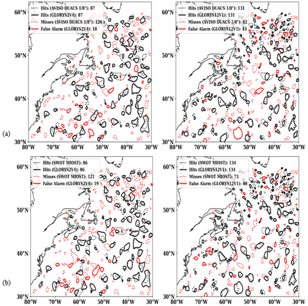
Abstract. Ocean mesoscale eddies (10–250 km) play a key role in transporting heat, momentum, and nutrients. Accurately evaluating their representation in ocean reanalysis becomes important given that ocean reanalysis is widely used in ocean and climate research due to their temporal and spatial consistent coverage. This study aims to assess two global ocean reanalysis products—GLORYS12V1 (1/12° resolution) and GLORYS2V4 (1/4° resolution) available from the Copernicus Marine Service—against satellite altimetry observations. We have used both AVISO SSALTO/DUACS (1/4°) and the higher-resolution AVISO SWOT MIOST Science product (1/8°), as reference datasets that allow us to understand better the advantage of high-resolution altimetry data and have a fair evaluation for eddy-resolving ocean reanalysis (1/12°). The evaluation approach is based on a feature-based eddy-verification method to compare eddy properties for example amplitude, radius, centroid, shape using a cost-function metric, Probability of Detection (POD) and False Alarm Ratio (FAR) are then used to quantify the reanalysis skill. GLORYS12V1 demonstrates better agreement with observations than GLORYS2V4, especially for eddies with amplitudes >10 cm. For both DUACS and SWOT MIOST Science, the POD increases by more than 30 % when moving from GLORYS2V4 to GLORYS12V1, while the FAR also rises by about 20 %, mainly due to the detection of more small and weak eddies. The hit-cost metrics also improve with SWOT, the total hit cost decreases by more than 9 %, and the amplitude error is reduced by about 6 %. Small increases in radius and distance between centroids are still observed, but these are smaller in the SWOT comparison, showing better compatibility with the high-resolution reanalysis. Overall, POD values remain above 50 % and reach around 60 % with SWOT, while FAR stays below 30 %. These results underline the added value of high model resolution for the representation mesoscale eddies in ocean reanalyses and highlight the value of wide-swath altimetry for model verification.
Competing interests: At least one of the (co-)authors is a guest member of the editorial board of Ocean Science for the special issue "Evaluation of ocean reanalyses to meet users' needs". The peer-review process was guided by an independent editor, and the authors also have no other competing interests to declare.
Publisher's note: Copernicus Publications remains neutral with regard to jurisdictional claims made in the text, published maps, institutional affiliations, or any other geographical representation in this paper. While Copernicus Publications makes every effort to include appropriate place names, the final responsibility lies with the authors. Views expressed in the text are those of the authors and do not necessarily reflect the views of the publisher.-
Notice on discussion status
The requested preprint has a corresponding peer-reviewed final revised paper. You are encouraged to refer to the final revised version.
-
Preprint
(3640 KB)
-
The requested preprint has a corresponding peer-reviewed final revised paper. You are encouraged to refer to the final revised version.
- Preprint
(3640 KB) - Metadata XML
- BibTeX
- EndNote
- Final revised paper


Journal article(s) based on this preprint
Interactive discussion
Status: closed
-
RC1: 'Comment on egusphere-2026-2257', Anonymous Referee #1, 21 May 2026
The comment was uploaded in the form of a supplement: https://egusphere.copernicus.org/preprints/2026/egusphere-2026-2257/egusphere-2026-2257-RC1-supplement.pdfCitation: https://doi.org/
10.5194/egusphere-2026-2257-RC1 -
AC1: 'Reply on RC1', Paolo Mauriello, 17 Jul 2026
We sincerely thank Anonymous Referee #1 for the careful evaluation of our manuscript and for the constructive comments and suggestions. We have addressed all comments individually and revised the manuscript accordingly. A detailed response, including the corresponding changes made in the revised manuscript, is provided in the attached PDF.
-
AC1: 'Reply on RC1', Paolo Mauriello, 17 Jul 2026
-
RC2: 'Comment on egusphere-2026-2257', Anonymous Referee #2, 11 Jun 2026
-
AC2: 'Reply on RC2', Paolo Mauriello, 17 Jul 2026
We sincerely thank Anonymous Referee #2 for the careful evaluation of our manuscript and for the constructive comments and suggestions. We have addressed all comments individually and revised the manuscript accordingly. A detailed response, including the corresponding changes made in the revised manuscript, is provided in the attached PDF.
-
AC2: 'Reply on RC2', Paolo Mauriello, 17 Jul 2026
Peer review completion


Interactive discussion
Status: closed
-
RC1: 'Comment on egusphere-2026-2257', Anonymous Referee #1, 21 May 2026
The comment was uploaded in the form of a supplement: https://egusphere.copernicus.org/preprints/2026/egusphere-2026-2257/egusphere-2026-2257-RC1-supplement.pdf
-
AC1: 'Reply on RC1', Paolo Mauriello, 17 Jul 2026
We sincerely thank Anonymous Referee #1 for the careful evaluation of our manuscript and for the constructive comments and suggestions. We have addressed all comments individually and revised the manuscript accordingly. A detailed response, including the corresponding changes made in the revised manuscript, is provided in the attached PDF.
-
AC1: 'Reply on RC1', Paolo Mauriello, 17 Jul 2026
-
RC2: 'Comment on egusphere-2026-2257', Anonymous Referee #2, 11 Jun 2026
-
AC2: 'Reply on RC2', Paolo Mauriello, 17 Jul 2026
We sincerely thank Anonymous Referee #2 for the careful evaluation of our manuscript and for the constructive comments and suggestions. We have addressed all comments individually and revised the manuscript accordingly. A detailed response, including the corresponding changes made in the revised manuscript, is provided in the attached PDF.
-
AC2: 'Reply on RC2', Paolo Mauriello, 17 Jul 2026
Peer review completion
Journal article(s) based on this preprint
Viewed
| HTML | XML | Total | BibTeX | EndNote | |
|---|---|---|---|---|---|
| 354 | 212 | 48 | 614 | 34 | 31 |
- HTML: 354
- PDF: 212
- XML: 48
- Total: 614
- BibTeX: 34
- EndNote: 31
Viewed (geographical distribution)
| Country | # | Views | % |
|---|
| Total: | 0 |
| HTML: | 0 |
| PDF: | 0 |
| XML: | 0 |
- 1

Gregory C. Smith
Andrea Storto
Chunxue Yang
The requested preprint has a corresponding peer-reviewed final revised paper. You are encouraged to refer to the final revised version.
- Preprint
(3640 KB) - Metadata XML