
the Creative Commons Attribution 4.0 License.
the Creative Commons Attribution 4.0 License.
 | 01 Dec 2025
Lake Victoria to the Sudd Wetland: flood wave timing, connectivity and wetland buffering across the White Nile
Abstract. The White Nile from Lake Victoria through Lakes Kyoga and Albert to the Sudd forms a complex lake-river-wetland corridor where flood propagation, storage, and attenuation remain poorly quantified. Following unprecedented and persistent flooding across South Sudan in 2022, this study quantified how long it takes a flood wave to travel from Lake Victoria to the Sudd and how upstream storage and connectivity shape multi-year flood behaviour. Using daily lake levels, discharge, CHIRPS rainfall, and MODIS-derived inundation for 2002–2024, we tracked sequential flood peaks through the Victoria–Kyoga–Albert–Sudd cascade and mapped monthly wetland dynamics across five South Sudan sub-catchments. Flood-wave tracking showed a mean system transit time of 16.84 ± 1.95 months (range 13.0–20.9 months), overturning the long-held assumption of a five-month propagation. Segmental analysis revealed rapid transmission from Victoria to Kyoga (mean 4.2 months) but strong attenuation through the Albert–Sudd reach (mean 9.3 months), consistent with extensive floodplain storage and backwater control. Correlations between Lake Victoria peaks and downstream wetland extents strengthened markedly after 2019, with r² exceeding 0.8 at 9–13-month lags, confirming strong hydraulic coupling and long system memory. The 2019–2024 high-water regime was therefore not a series of isolated rainfall events but a multi-year propagation of excess storage initiated by the 2019 positive Indian Ocean Dipole anomaly and consecutive rainfall seasons. When compared with historical episodes in the 1870s and 1960s, the persistence and spatial reach of the 2019–2024 floods rank among the most extensive in the modern record. These results redefine the White Nile as a long-memory system where upstream storage governs downstream flood risk, offering a new empirical basis for flood forecasting, wetland management, and anticipatory action in South Sudan and the wider basin.
-
Notice on discussion status
The requested preprint has a corresponding peer-reviewed final revised paper. You are encouraged to refer to the final revised version.
-
Preprint
(2756 KB)
-
The requested preprint has a corresponding peer-reviewed final revised paper. You are encouraged to refer to the final revised version.
- Preprint
(2756 KB) - Metadata XML
- BibTeX
- EndNote
- Final revised paper


Journal article(s) based on this preprint
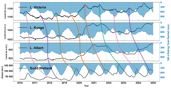
This study traced how water moved from Lake Victoria to the Sudd wetlands to explain the prolonged flooding in South Sudan between 2019 and 2024. Using satellite observations, rainfall records, and lake and river measurements, we found that water takes about 17 months to travel through the system, much longer than previously assumed 5 months. The results show that lakes and wetlands can store and slowly release water over several years, helping improve flood forecasting and early warning.
Interactive discussion
Status: closed
-
RC1: 'Comment on egusphere-2025-5009', Anonymous Referee #1, 23 Jan 2026
- AC1: 'Reply on RC1', Douglas Mulangwa, 06 Mar 2026
-
RC2: 'Comment on egusphere-2025-5009', Anonymous Referee #2, 05 Feb 2026
I really enjoyed this study illustrating how to accurately consider buffering of floods in the areas downstream to Lake Victoria.
The authors make a very interesting effort in collecting and combining off-the-shelf open-data information and local information. They manage developing a robust analysis framework to gain insights on the propagation of flood waves across this system characterized by important wetland areas. The analyses and findings are very relevant for water resources management in this large area. Furthermore, the diversity of events analysis within the 2019-2024 provides baseline to better anticipate flood hazards mitigation in the region.
Personally, I have only a request and a concern about this manuscript.
My request is that sections 2.5.x should be supported by a graphical abstract illustrating the different steps.
My concern is that despite the excellent quality of the manuscript, this study fails both by not introducing novel methos and not illustrating a broadly applicable setup.
In my assessment this study would be a perfect contribution for “Journal of Hydrology, Regional Studies”. The standard scopes of HESS are in my opinion poorly met.
I am nevertheless ready to reconsider my opinion upon the judgements of the editor and of the other reviewers.
Citation: https://doi.org/10.5194/egusphere-2025-5009-RC2 - AC2: 'Reply on RC2', Douglas Mulangwa, 06 Mar 2026
Peer review completion


Interactive discussion
Status: closed
-
RC1: 'Comment on egusphere-2025-5009', Anonymous Referee #1, 23 Jan 2026
Reviewer report
This study used data-driven, Earth observation data and statistical techniques to unravel how flood peaks were transformed and transmitted from Lake Victoria through Lakes Kyoga and Albert to the Sudd which forms a complex system from 2000 to 2024 with specific attention to the 2019-2024 flooding events.
Strengths and significance of the manuscript
- The manuscript presents a coherent, system‑scale analysis of a lake–river–wetland continuum and treats the Sudd wetland as an integrated storage node within the complex system.
- The workflow is transparent and reproducible with fixed search windows, and physically interpretable results across different segments of the complex system.
- Distinguishes clearly between physical flood‑wave transit times and statistical lag/correlation and uses the latter only as supporting evidence for connectivity and memory.
- Presents the multi‑year memory narrative with salient evidence in the form of numbers: E.g., Sudd wetland maximum extent of 163,475 km² in 2022 and repeated Lake Victoria record highs (2020, 2021, 2024).
- The findings that Victoria-Kyoga-Albert-Sudd average transit time is about 16.84 months may supplant long-held narrative that this transit time is about 5 months. Given the empirical evidence presented this finding may have long-term direct implications for anticipatory action/seasonal outlook design across the White Nile.
- The results of this study unravel the complex interaction within a cascade of lakes, river and wetland in the study area and will be critical to enhancing flood forecasting in South Sudan.
- The findings presented in this study will be invaluable to the National Meteorological and Hydrological Services in the region particularly South Sudan and other organisations involved in disaster risk management in the region such as the Red Cross, World Food Program and UNHCR.
Whilst I acknowledge that this is a strong manuscript with a transparent methodology that can be replicated in other regions; there a couple of issues which I suggest the authors should address before the manuscript can be accepted for publication. These issues range from moderate to minor and does not require a substantial revision of the manuscript. Well done to the authors!
Moderate comments:
- Given the length of the paper, the authors may want to state central claim of the paper which is “the 16.84 months system transit time” which is mentioned in the abstract and only appears again in section 3.3. The authors may want to explicitly contrast it with the commonly held believe that the system transit time is about 5 months to sharpen novelty. This may appear at the end of the introduction.
- There is inconsistency in paragraphs lengths especially in the introduction section of the manuscript. For example, compare L35-50, L51- 62, L104-108, L110-126 etc. If possible, the authors should aim to harmonize paragraph lengths to improve readability, unless there is a clear rationale for maintaining the current structure.
- For sensitivity of event matching parameter, whilst the prominence threshold (δ), smoothing window (±15 days), and the 335‑day search horizon are defensible, the paper would benefit from a short supplementary sensitivity analysis. For example, show how Victoria-Kyoga-Albert-Sudd lag changes under (i) 7 days smoothing window, and (ii) ±2 months search horizon. This will strengthen confidence that the 16–17‑month figure is not the result of the authors subjective decisions.
- The authors highlighted the absence of publicly available Lake Victoria outflow records; please could the authors add one paragraph in Methods or Discussion section to clarify how this limitation could (or could not) bias the transit‑time inference, given that the method uses observed peak lake levels and downstream signals rather than release series.
- Could the authors add a link to the MODIS-based inundation masks produced and post-processed by the World Food Programme (WFP) as many readers may not be aware that this dataset exits.
- Consistency in “physical” vs “statistical” timing across figures. section 3.3 shows physical transits (splines linking matched peaks), and section 3.4 shows r²‑vs‑lag curves, consider providing a statement to clarify “what the line connects” vs “what the correlation peak means”.
Minor comments
- The phrase “complex system with complex hydrology” appears multiple times in close proximity (opening paragraphs); please consider pruning or varying wording to avoid diluting a strong opening statement.
- Where you cite record Sudd extent (163,475 km² in 2022), place the number in the Abstract and include the six-year series for context (2019–2024).
- The terminology: “activation/backwater” is used appropriately; however, consider a one‑line parenthetical definition at first use to help non-specialist readers.
- L42 & L45: (Mohamed et al., 2005b, 2005a) (I think it should be 2005a, 2005b)
- L59: (Mohamed et al., 2005a, 2005b). This approach should be adopted throughout the manuscript.
- Figures, especially 5, 6 &7 are placed very far from where there are first mentioned in the manuscript. Considering moving figures closer to where they are first mentioned in the manuscript.
Recommendation: Minor decision
Rationale: The manuscript is substantively strong with very clear and reproducible methods, the central claim is important and well supported by data and results, and the contribution of the manuscript is extremely timely. Revisions requested are largely presentation/clarification and minor sensitivity checks, and do not question the methodology, discussion nor require any fundamental re-analysis of data or the use of new data.
Citation: https://doi.org/10.5194/egusphere-2025-5009-RC1 - AC1: 'Reply on RC1', Douglas Mulangwa, 06 Mar 2026
-
RC2: 'Comment on egusphere-2025-5009', Anonymous Referee #2, 05 Feb 2026
I really enjoyed this study illustrating how to accurately consider buffering of floods in the areas downstream to Lake Victoria.
The authors make a very interesting effort in collecting and combining off-the-shelf open-data information and local information. They manage developing a robust analysis framework to gain insights on the propagation of flood waves across this system characterized by important wetland areas. The analyses and findings are very relevant for water resources management in this large area. Furthermore, the diversity of events analysis within the 2019-2024 provides baseline to better anticipate flood hazards mitigation in the region.
Personally, I have only a request and a concern about this manuscript.
My request is that sections 2.5.x should be supported by a graphical abstract illustrating the different steps.
My concern is that despite the excellent quality of the manuscript, this study fails both by not introducing novel methos and not illustrating a broadly applicable setup.
In my assessment this study would be a perfect contribution for “Journal of Hydrology, Regional Studies”. The standard scopes of HESS are in my opinion poorly met.
I am nevertheless ready to reconsider my opinion upon the judgements of the editor and of the other reviewers.
Citation: https://doi.org/10.5194/egusphere-2025-5009-RC2 - AC2: 'Reply on RC2', Douglas Mulangwa, 06 Mar 2026
Peer review completion
Journal article(s) based on this preprint
This study traced how water moved from Lake Victoria to the Sudd wetlands to explain the prolonged flooding in South Sudan between 2019 and 2024. Using satellite observations, rainfall records, and lake and river measurements, we found that water takes about 17 months to travel through the system, much longer than previously assumed 5 months. The results show that lakes and wetlands can store and slowly release water over several years, helping improve flood forecasting and early warning.
Viewed
| HTML | XML | Total | BibTeX | EndNote | |
|---|---|---|---|---|---|
| 2,946 | 2,056 | 191 | 5,193 | 1,266 | 800 |
- HTML: 2,946
- PDF: 2,056
- XML: 191
- Total: 5,193
- BibTeX: 1,266
- EndNote: 800
Viewed (geographical distribution)
| Country | # | Views | % |
|---|
| Total: | 0 |
| HTML: | 0 |
| PDF: | 0 |
| XML: | 0 |
- 1
Cited


2 citations as recorded by crossref.
- 2019–2024 trends in African livestock and wetland emissions as contributors to the global methane rise N. Balasus et al. https://doi.org/10.5194/acp-26-4601-2026
- Multi-Objective Calibration of a Pre-Modern Nile Hydrologic Model Using Recovered Records I. Munyejuru & J. Stagge https://doi.org/10.3390/hydrology13040114
Douglas Mulangwa

Evet Naturinda
Charles Koboji
Benon T. Zaake
Emily Black
Hannah Cloke
Elisabeth M. Stephens
The requested preprint has a corresponding peer-reviewed final revised paper. You are encouraged to refer to the final revised version.
- Preprint
(2756 KB) - Metadata XML
Reviewer report
This study used data-driven, Earth observation data and statistical techniques to unravel how flood peaks were transformed and transmitted from Lake Victoria through Lakes Kyoga and Albert to the Sudd which forms a complex system from 2000 to 2024 with specific attention to the 2019-2024 flooding events.
Strengths and significance of the manuscript
Whilst I acknowledge that this is a strong manuscript with a transparent methodology that can be replicated in other regions; there a couple of issues which I suggest the authors should address before the manuscript can be accepted for publication. These issues range from moderate to minor and does not require a substantial revision of the manuscript. Well done to the authors!
Moderate comments:
Minor comments
Recommendation: Minor decision
Rationale: The manuscript is substantively strong with very clear and reproducible methods, the central claim is important and well supported by data and results, and the contribution of the manuscript is extremely timely. Revisions requested are largely presentation/clarification and minor sensitivity checks, and do not question the methodology, discussion nor require any fundamental re-analysis of data or the use of new data.