
the Creative Commons Attribution 4.0 License.
the Creative Commons Attribution 4.0 License.
 | 06 Oct 2025
From XRD signal to erosion rate maps
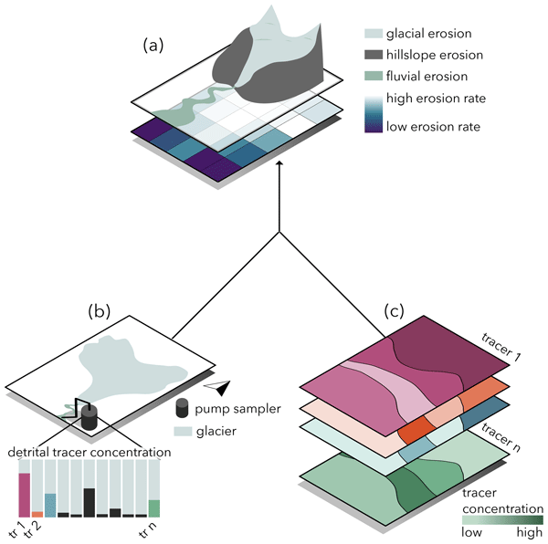
Abstract. Understanding the spatio-temporal dynamics of suspended sediment source activation is essential for effective ecological management, risk assessment, and infrastructure planning. Provenance analysis, which traces sediment origins, plays a crucial role in these applications, but is often based on costly fingerprinting methods. In this study, we validate a time- and cost-effective fingerprinting approach based on X-ray diffraction (XRD) data. We implement and compare two non-linear inversion schemes (steepest descent and Quasi-Newtonian) applied to binned XRD data and spatial information on potential source areas, in order to invert detrital mineralogical data into erosion rate maps while quantifying posterior uncertainty and error propagation. Forward-inverse tests with synthetic data demonstrate consistent convergence of the posterior solution. The application to real-world datasets further validates the practical utility and robustness of the model.
-
Notice on discussion status
The requested preprint has a corresponding peer-reviewed final revised paper. You are encouraged to refer to the final revised version.
-
Preprint
(23108 KB)
-
The requested preprint has a corresponding peer-reviewed final revised paper. You are encouraged to refer to the final revised version.
- Preprint
(23108 KB) - Metadata XML
- BibTeX
- EndNote
- Final revised paper


Journal article(s) based on this preprint
Interactive discussion
Status: closed
-
RC1: 'Comment on egusphere-2025-4695', Anonymous Referee #1, 15 Nov 2025
- AC1: 'Reply on RC1', Fien De Doncker, 11 Mar 2026
-
RC2: 'Comment on egusphere-2025-4695', Mikaël Attal, 12 Feb 2026
Dear editor, dear authors,
I really enjoyed reading this article which presents a very original and potentially promising fingerprinting approach that involves cost-effective XRD analysis on fine sediment.
The manuscript is very well-written and presented (although the introduction is repeated), with a very clear argument and beautiful figures that are efficiently used to support the argument. I like the presentation of the methods, the validation that uses both synthetic and natural datasets, and the discussion of the opportunities and limitations.
My main comments are about the limitations. Firstly, I would like to know more about the grain size of the sediment sampled (suspended sediment), and how it compares to the ground bedrock samples. I assume a significant part of these grains will be in the silt/clay fraction, where minerals formed as a result of chemical weathering may abound. The presence of such minerals in the sampled suspended sediment may cause errors, as they wouldn’t feature in the crushed bedrock. This may be an argument that supports the use of this method in places with low chemical weathering intensity (as in this study – mountainous / polar regions), but may prescribe its use in other areas (tropical)? Can the choice of target minerals help avoid this problem?
Secondly, I feel that there could be a bias associated with the way sediment grains of various sizes may be preferentially produced by the weathering/erosion of some particular rock types, and/or the action of specific processes. I note that this probably applies to all fingerprinting methods, but could be particularly relevant to this study that stresses the need for strong mineralogical differences between units for the method to produce satisfying results, and the mention of glacial processes. This work illustrates nicely that this can cause enormous problems, with the low zircon concentration in the ophiolite units mentioned as a potential cause for the highly unstable results of the inversion of the zircon data (i.e., erosion rates > 8,000 mm/yr). Could the weathering/erosion of granite produce more grains in the sand fraction, while the weathering/erosion of serpentinite and slates/schist produce more grains in the silt/clay fraction? This has been observed in the abrasion of pebbles of different lithologies, so could potentially apply here? Additionally, glacial processes may produce more clay-size sediment (glacial flour) compared to other processes elsewhere in the catchment. This is why I feel the reader needs to know more about the grain size of the sediment analysed; these potential issues could also be discussed further in the discussion, if the authors felt it would be useful.
Finally, some minor comments:
- the following paper may be relevant: Sediment tracing in the upper Hunter catchment using elemental and mineralogical compositions: Implications for catchment-scale suspended sediment (dis)connectivity and management. Kirstie Fryirs, Damian Gore. Geomorphology 193 (2013) 112–121. http://dx.doi.org/10.1016/j.geomorph.2013.04.010.
- Some methods are criticised because “they link sediment directly to its origin, without modelling storage or transport”, but I don’t think the new approach models storage or transport either?
- The abstract could be more specific about the specific findings of the work
I hope you find these comments helpful.
Mikael Attal
Citation: https://doi.org/10.5194/egusphere-2025-4695-RC2 -
AC2: 'Reply on RC2', Fien De Doncker, 11 Mar 2026
We thank the reviewer for taking the time to provide thoughtful and constructive feedback. These comments have helped us improve the clarity of the manuscript. In the attached document, we provide detailed point-by-point responses to all comments raised.
Peer review completion


Interactive discussion
Status: closed
-
RC1: 'Comment on egusphere-2025-4695', Anonymous Referee #1, 15 Nov 2025
DeDonker et al. present a novel and ambitious inverse methodology to infer maps of erosion rates from mineralogical data derived from XRD analysis of suspended sediments. Their method defines a model matrix, which uses bedrock mineralogy data also from XRD analysis and a geological map to characterise the catchment, and then uses a non-linear inversion to infer erosion rates based on the mineralogical data of the suspended sediments. They provide a thorough analysis of the inversion method, including testing two different inverse schemes, as well as testing a wide range of various parameter values to explore their limitations. Having done this, they then apply their method to the Gornergletscher catchment, presenting an erosion rate map for the area. Generally I found the manuscript to be well written, and will likely be suitable for publication following some further exploration/explanation of the limitations of the inversion.
Firstly, I think the authors do an excellent job of acknowledging and testing many of the limitations of the inversion, and so I commend them for this. However, I found some of the presentation of the scatter plots in figures 7-10 to be slightly unintuitive. It would be really helpful, perhaps in a supplement, or alongside these figures, that the resulting erosion rate maps of the synthetic tests are shown. Of course, it would be nice to see all of them, but perhaps 3 for each parameter tested would aid the reader in understanding how different the inversion result can be. For example, what do the three erosion rate maps look like for the three different geological map inputs? Perhaps the results are very similar, but at the moment, it is difficult to infer how much variation is possible for the model results based on different inversion parameters being changed.
On this note, I perhaps would also like to see a more complex synthetic test set up than the one presented. Something akin to a checkerboard test might be ideal, or a scenario where there are more than one peak in erosion rate. From what I can tell, the present synthetic test has high erosion rates across two similar lithologies (Stockhorn-Turftgrat-Gornergrat and ZSF ophiolites?), and low rates elsewhere. This is quite a simple set up. Would the inversion scheme be able to identify two different peaks of erosion that are spatially discrete within these two units? What about three peaks spread out across the catchment? Hence, I would like to see a slightly more complex synthetic erosion rate map tested. Having said this, I did like the testing of two different inversion schemes on the synthetic data to decide which one is more suitable – nice analysis.
Finally, I felt that the XRD data needed explaining a little better and perhaps slightly more exploration of the associated errors. For instance, the number of bedrock XRD analyses is not stated. I wondered whether if only one per lithology were analysed, how different two samples from the same lithology could be, and how much error this could introduce? If only one is used per lithology, is the assumption that each mapped lithology is homogenous fair? From what I can tell from the unit descriptions they can be quite variable. How is this variability accounted for? Hence, I would like to firstly see greater detail given for the acquisition of XRD data and mineralogy data, and perhaps some exploration of inversion results akin the analysis presented in figure 8 for an error introduced when the measured bedrock mineralogy is different from the true bedrock mineralogy. Here you could synthesise a sediment mineralogy based on one set of bedrock mineralogies, and then randomly change each mineralogy in the A matrix by some value of the ‘error’. I am not sure whether this is reasonable or not however, as I am not an expert in XRD, and I am not sure how the bedrock XRD data was collected.
One final comment, the introduction is duplicated. One needs to be removed, and the section numbers redone.
I hope the authors find these help to improve the manuscript. I also outline a few line comments below.
Line 61 – Should be an in-text citation.
Line 270ish Gorner-gletscher then gornergletcher, needs to be consistent throughout the manuscript.
Figure 7. Originial geology – should be original.
Citation: https://doi.org/10.5194/egusphere-2025-4695-RC1 - AC1: 'Reply on RC1', Fien De Doncker, 11 Mar 2026
-
RC2: 'Comment on egusphere-2025-4695', Mikaël Attal, 12 Feb 2026
Dear editor, dear authors,
I really enjoyed reading this article which presents a very original and potentially promising fingerprinting approach that involves cost-effective XRD analysis on fine sediment.
The manuscript is very well-written and presented (although the introduction is repeated), with a very clear argument and beautiful figures that are efficiently used to support the argument. I like the presentation of the methods, the validation that uses both synthetic and natural datasets, and the discussion of the opportunities and limitations.
My main comments are about the limitations. Firstly, I would like to know more about the grain size of the sediment sampled (suspended sediment), and how it compares to the ground bedrock samples. I assume a significant part of these grains will be in the silt/clay fraction, where minerals formed as a result of chemical weathering may abound. The presence of such minerals in the sampled suspended sediment may cause errors, as they wouldn’t feature in the crushed bedrock. This may be an argument that supports the use of this method in places with low chemical weathering intensity (as in this study – mountainous / polar regions), but may prescribe its use in other areas (tropical)? Can the choice of target minerals help avoid this problem?
Secondly, I feel that there could be a bias associated with the way sediment grains of various sizes may be preferentially produced by the weathering/erosion of some particular rock types, and/or the action of specific processes. I note that this probably applies to all fingerprinting methods, but could be particularly relevant to this study that stresses the need for strong mineralogical differences between units for the method to produce satisfying results, and the mention of glacial processes. This work illustrates nicely that this can cause enormous problems, with the low zircon concentration in the ophiolite units mentioned as a potential cause for the highly unstable results of the inversion of the zircon data (i.e., erosion rates > 8,000 mm/yr). Could the weathering/erosion of granite produce more grains in the sand fraction, while the weathering/erosion of serpentinite and slates/schist produce more grains in the silt/clay fraction? This has been observed in the abrasion of pebbles of different lithologies, so could potentially apply here? Additionally, glacial processes may produce more clay-size sediment (glacial flour) compared to other processes elsewhere in the catchment. This is why I feel the reader needs to know more about the grain size of the sediment analysed; these potential issues could also be discussed further in the discussion, if the authors felt it would be useful.
Finally, some minor comments:
- the following paper may be relevant: Sediment tracing in the upper Hunter catchment using elemental and mineralogical compositions: Implications for catchment-scale suspended sediment (dis)connectivity and management. Kirstie Fryirs, Damian Gore. Geomorphology 193 (2013) 112–121. http://dx.doi.org/10.1016/j.geomorph.2013.04.010.
- Some methods are criticised because “they link sediment directly to its origin, without modelling storage or transport”, but I don’t think the new approach models storage or transport either?
- The abstract could be more specific about the specific findings of the work
I hope you find these comments helpful.
Mikael Attal
Citation: https://doi.org/10.5194/egusphere-2025-4695-RC2 -
AC2: 'Reply on RC2', Fien De Doncker, 11 Mar 2026
We thank the reviewer for taking the time to provide thoughtful and constructive feedback. These comments have helped us improve the clarity of the manuscript. In the attached document, we provide detailed point-by-point responses to all comments raised.
Peer review completion
Journal article(s) based on this preprint
Data sets
Non-Linear-XRD-Inversion: First public release – From XRD to erosion rate maps Fien De Doncker et al. https://doi.org/10.5281/zenodo.17120374
Viewed
| HTML | XML | Total | BibTeX | EndNote | |
|---|---|---|---|---|---|
| 1,980 | 1,689 | 198 | 3,867 | 178 | 277 |
- HTML: 1,980
- PDF: 1,689
- XML: 198
- Total: 3,867
- BibTeX: 178
- EndNote: 277
Viewed (geographical distribution)
| Country | # | Views | % |
|---|
| Total: | 0 |
| HTML: | 0 |
| PDF: | 0 |
| XML: | 0 |
- 1

Frédéric Herman
Bruno Belotti
Thierry Adatte
The requested preprint has a corresponding peer-reviewed final revised paper. You are encouraged to refer to the final revised version.
- Preprint
(23108 KB) - Metadata XML
DeDonker et al. present a novel and ambitious inverse methodology to infer maps of erosion rates from mineralogical data derived from XRD analysis of suspended sediments. Their method defines a model matrix, which uses bedrock mineralogy data also from XRD analysis and a geological map to characterise the catchment, and then uses a non-linear inversion to infer erosion rates based on the mineralogical data of the suspended sediments. They provide a thorough analysis of the inversion method, including testing two different inverse schemes, as well as testing a wide range of various parameter values to explore their limitations. Having done this, they then apply their method to the Gornergletscher catchment, presenting an erosion rate map for the area. Generally I found the manuscript to be well written, and will likely be suitable for publication following some further exploration/explanation of the limitations of the inversion.
Firstly, I think the authors do an excellent job of acknowledging and testing many of the limitations of the inversion, and so I commend them for this. However, I found some of the presentation of the scatter plots in figures 7-10 to be slightly unintuitive. It would be really helpful, perhaps in a supplement, or alongside these figures, that the resulting erosion rate maps of the synthetic tests are shown. Of course, it would be nice to see all of them, but perhaps 3 for each parameter tested would aid the reader in understanding how different the inversion result can be. For example, what do the three erosion rate maps look like for the three different geological map inputs? Perhaps the results are very similar, but at the moment, it is difficult to infer how much variation is possible for the model results based on different inversion parameters being changed.
On this note, I perhaps would also like to see a more complex synthetic test set up than the one presented. Something akin to a checkerboard test might be ideal, or a scenario where there are more than one peak in erosion rate. From what I can tell, the present synthetic test has high erosion rates across two similar lithologies (Stockhorn-Turftgrat-Gornergrat and ZSF ophiolites?), and low rates elsewhere. This is quite a simple set up. Would the inversion scheme be able to identify two different peaks of erosion that are spatially discrete within these two units? What about three peaks spread out across the catchment? Hence, I would like to see a slightly more complex synthetic erosion rate map tested. Having said this, I did like the testing of two different inversion schemes on the synthetic data to decide which one is more suitable – nice analysis.
Finally, I felt that the XRD data needed explaining a little better and perhaps slightly more exploration of the associated errors. For instance, the number of bedrock XRD analyses is not stated. I wondered whether if only one per lithology were analysed, how different two samples from the same lithology could be, and how much error this could introduce? If only one is used per lithology, is the assumption that each mapped lithology is homogenous fair? From what I can tell from the unit descriptions they can be quite variable. How is this variability accounted for? Hence, I would like to firstly see greater detail given for the acquisition of XRD data and mineralogy data, and perhaps some exploration of inversion results akin the analysis presented in figure 8 for an error introduced when the measured bedrock mineralogy is different from the true bedrock mineralogy. Here you could synthesise a sediment mineralogy based on one set of bedrock mineralogies, and then randomly change each mineralogy in the A matrix by some value of the ‘error’. I am not sure whether this is reasonable or not however, as I am not an expert in XRD, and I am not sure how the bedrock XRD data was collected.
One final comment, the introduction is duplicated. One needs to be removed, and the section numbers redone.
I hope the authors find these help to improve the manuscript. I also outline a few line comments below.
Line 61 – Should be an in-text citation.
Line 270ish Gorner-gletscher then gornergletcher, needs to be consistent throughout the manuscript.
Figure 7. Originial geology – should be original.