
the Creative Commons Attribution 4.0 License.
the Creative Commons Attribution 4.0 License.
 | 11 Mar 2026
Vertical Profiles of Aerosol Chemical Species Concentration retrieved through Synergy of Spaceborne Lidar and Polarimeter Observations
Abstract. We present a novel methodology, AEROCHEMPro/GRASP (AEROsol CHEMical PROfiling), for retrieving vertical concentration profiles of aerosol chemical species by synergistically combining co-located measurements from a multiwavelength lidar and a multi-angular polarimeter. AEROCHEMPro represents the first retrieval framework for remote sensing of the vertically-resolved aerosol chemical composition, and it is based on an improved, vertical profiling version of the GRASP (Generalized Retrieval of Aerosol and Surface Properties) chemical component framework. The methodology is developed within the context of the Atmosphere Observing System (AOS) international initiative, which proposes a spaceborne observing system to advance our knowledge of aerosols, clouds, convection, and precipitation. Moreover, the retrieval strategy remains broadly applicable to future satellite missions and observing systems involving combined lidar and multi-angular polarimeter aerosol remote sensing.
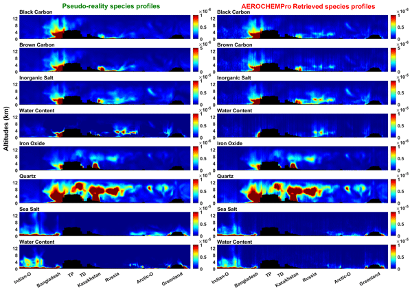
Based on a statistically optimized and physically-constrained inversion, AEROCHEMPro/GRASP delivers three distinct aerosol vertical profiles: (i) a fine mode composed of black carbon, brown carbon, inorganic salts, and associated water uptake; (ii) a coarse mode representing mineral dust, decomposed into iron oxide and quartz species; and (iii) a hydrophilic coarse mode consisting of sea salt particles and their associated water content. The approach explicitly retrieves these three aerosol profiles, along with the fractional abundance of each of the six mentioned aerosol chemical species and their water content. This retrieval of aerosol chemical composition vertical profiles offers, for the first time, a direct observational link between aerosol optical measurements and their speciation resolved in altitude. We demonstrate the feasibility and performance of this technique through an innovative retrieval experiment, where synthetic lidar and polarimeter observations are generated using the MOCAGE chemical transport model and a comprehensive radiative transfer simulator. These pseudo-observations include multi-wavelength attenuated backscatter and depolarization ratios, along with polarized radiances across multiple viewing angles and spectral bands.
Results from global-scale transects spanning marine, urban, dust, and complex mixture-dominated regions show that the retrieval captures with good fidelity the main features of vertical aerosol composition and their bulk optical properties. Fine-mode species are well retrieved, particularly in the boundary layer, even for atmospheres with complex mixtures of multiple aerosol species. Dust is accurately retrieved and well defined in terms of vertical extent, load, and composition, and sea salt concentrations are very well reproduced. Some limitations for deriving water content in the upper atmospheric layers are remarked. AEROCHEMPro/GRASP reliably derives optical properties such as aerosol optical depth (AOD), single scattering albedo (SSA), and lidar ratio (LR), demonstrating the approach's robustness. This new retrieval approach represents a significant advancement in spaceborne aerosol remote sensing, as it provides vertically resolved chemical speciation that is directly related to chemical transport model results. It offers new opportunities to improve our understanding of aerosol processes and their effects on climate and air quality.
Competing interests: At least one of the (co-)authors is a member of the editorial board of Atmospheric Measurement Techniques.
Publisher's note: Copernicus Publications remains neutral with regard to jurisdictional claims made in the text, published maps, institutional affiliations, or any other geographical representation in this paper. While Copernicus Publications makes every effort to include appropriate place names, the final responsibility lies with the authors. Views expressed in the text are those of the authors and do not necessarily reflect the views of the publisher.-
Notice on discussion status
The requested preprint has a corresponding peer-reviewed final revised paper. You are encouraged to refer to the final revised version.
-
Preprint
(4277 KB)
-
Supplement
(353 KB)
-
The requested preprint has a corresponding peer-reviewed final revised paper. You are encouraged to refer to the final revised version.
- Preprint
(4277 KB) - Metadata XML
-
Supplement
(353 KB) - BibTeX
- EndNote
- Final revised paper


Journal article(s) based on this preprint
Interactive discussion
Status: closed
-
RC1: 'Comment on egusphere-2026-767', Anonymous Referee #1, 30 Mar 2026
-
AC1: 'Reply on RC1', Abou Bakr Merdji, 14 Jun 2026
We thank the reviewer for the positive assessment of our revised manuscript and for acknowledging that all previous comments have been satisfactorily addressed. We appreciate the time and effort invested in reviewing our work and are grateful for the recommendation to publish the manuscript
Citation: https://doi.org/10.5194/egusphere-2026-767-AC1
-
AC1: 'Reply on RC1', Abou Bakr Merdji, 14 Jun 2026
-
RC2: 'Review of egusphere-2026-767', Anonymous Referee #2, 08 May 2026
This is a review of the manuscript titled “Vertical Profiles of Aerosol Chemical Species Concentration retrieved through Synergy of Spaceborne Lidar and Polarimeter Observations” submitted to AMT by Merdji et al.
The paper describes an analysis of the performance of the AEROCHEMPro algorithm to retrieve aerosol properties from combined lidar and polarimeter data, based on simulated observations. The subject is very relevant as the combinatiomn of lidar and polarimeter is very promising to advance aerosol observations. The paper is generally well written and figures are clear. However, there are many limitations and assumptions that need to be explained and highlighted more before the paper can be accepted. Hence major revisions are needed as detailed below.
Limitations leading to optimistic results:
There are many limitations and simplications in the work and analysis that need to be explained and highlighted more. I understand many assumptions are due to practical limitations of the analysis and some is left to future work. However, they need to be clearly stated in the manuscript and in the abstract and conclusions to inform the reader of the scope of the paper. Especially the implications of these simplifications need to be made clear, as they may mostly lead to overly optimistic results. Limitations that I identified are listed below.
- If I understand correctly, the forward model and assumptions for the simulated observations and the retrievals are entirely consistent. Hence they make the same simplifications. I I amd correct, please make this explictely clear. This will result in a overly optimistic result, which then also need to be discussed.
- The surface parameters are not fitted according to section 2.1.6. Partitioning between aerosol and surface signals is one of the main challenges in aerosol remote sensing, so this is a very important limitation again leading to overly optimistic results.
- From the very low differences between simulated and retrieved U/I in table X, I suspect that the geometries used for the observations and retrievals are all assuming the principal plane, in which U is essentially zero. Polarimetric retrievals are sensitive to geometry and a principal plane geometry may be consisdered a best-case scenario. Please make clear which geometry is used and discuss the implications of the simplifications in this assumption (if applicable).
- The first guess used in the inversion is very important, as a first guess too far away from the truth may result in a non-covergence, while using the truth as first guess may lead to overly optimistic results. The first guess is not discussed in the manuscript, neither is a definition of (non-)convergence. Please discuss this and also the implication if a overly optimistic first guess is used (if applicable).
- In line 732 it is mentioned that only cases with AOD>0.1 are consisdered. Most of the global AOD values are below 0.1, so this is is also a limitation that need to be highlighted more.
Polarimeter noise assumptions:
Generally multi-angle polarimeters aim for an absolute accuracy of the degree of linear polarization (DoLP) better than 0.005, as also indicated for the AOS-MAP in line 456. In their error model, the authors add 3% noise to I and 0.5% noise to Q and U. Depending on the specific values of I, Q, U and DoLP, this can lead to noise greater or smaller than 0.005 on DoLP. Please discuss in the paper the relation between the choises made for the applied noise and the target of DoLP absolute uncertainties being below 0.005.
Other specific comments:
Table 3 : The number of significant digits varies throughout the table. Please make this consistent.
Table 4: There are additional entries for Nadir resolution and Swath width in the table. I assume these are threshold values. Please make this clear.
Line 500: Please do not use math mode for the text in the equations
Section 2.3.1: Here the surface parameters are described as part of the retrievals set up. However, they are not retrieved according to section 2.1.6. It is unclear how the surface parameters are kept fixed. Is that through the gamma assumptions? Please explain clearly in the text that the surface parametrs are fixed and how this is achieved.
Line 610 and further: Instead of “10-5” use E or superscript.
Figure 7:
- How do these differences relate to the added noise levels? Explain in the manuscript
- As discussed in the main comments I suspect that the geometries are assumed to be principal plane, in which U is zero. It then is also meaningless to report on the errors on U, so then I suggest to leave this out and explain in the text.
Line 665: These claims on AOD per specie nessecitate the reader to look at the supplement figure. I suggest adding it in the main text or limit this text to general statements.
Figure 9: LR and SSA are vertically varying parameters, but only one value is plotted here. What is the definition of reported LR and SSA here (and in section 3.2)? Please explain in the manuscript
711: Please change "surface-2km" to “between surface and 2km” or something similar
Citation: https://doi.org/10.5194/egusphere-2026-767-RC2 -
AC2: 'Reply on RC2', Abou Bakr Merdji, 14 Jun 2026
The comment was uploaded in the form of a supplement: https://egusphere.copernicus.org/preprints/2026/egusphere-2026-767/egusphere-2026-767-AC2-supplement.pdf
Peer review completion


Interactive discussion
Status: closed
-
RC1: 'Comment on egusphere-2026-767', Anonymous Referee #1, 30 Mar 2026
The authors have addressed all my previous comments. I recommend publication in its current form.
Citation: https://doi.org/10.5194/egusphere-2026-767-RC1 -
AC1: 'Reply on RC1', Abou Bakr Merdji, 14 Jun 2026
We thank the reviewer for the positive assessment of our revised manuscript and for acknowledging that all previous comments have been satisfactorily addressed. We appreciate the time and effort invested in reviewing our work and are grateful for the recommendation to publish the manuscript
Citation: https://doi.org/10.5194/egusphere-2026-767-AC1
-
AC1: 'Reply on RC1', Abou Bakr Merdji, 14 Jun 2026
-
RC2: 'Review of egusphere-2026-767', Anonymous Referee #2, 08 May 2026
This is a review of the manuscript titled “Vertical Profiles of Aerosol Chemical Species Concentration retrieved through Synergy of Spaceborne Lidar and Polarimeter Observations” submitted to AMT by Merdji et al.
The paper describes an analysis of the performance of the AEROCHEMPro algorithm to retrieve aerosol properties from combined lidar and polarimeter data, based on simulated observations. The subject is very relevant as the combinatiomn of lidar and polarimeter is very promising to advance aerosol observations. The paper is generally well written and figures are clear. However, there are many limitations and assumptions that need to be explained and highlighted more before the paper can be accepted. Hence major revisions are needed as detailed below.
Limitations leading to optimistic results:
There are many limitations and simplications in the work and analysis that need to be explained and highlighted more. I understand many assumptions are due to practical limitations of the analysis and some is left to future work. However, they need to be clearly stated in the manuscript and in the abstract and conclusions to inform the reader of the scope of the paper. Especially the implications of these simplifications need to be made clear, as they may mostly lead to overly optimistic results. Limitations that I identified are listed below.
- If I understand correctly, the forward model and assumptions for the simulated observations and the retrievals are entirely consistent. Hence they make the same simplifications. I I amd correct, please make this explictely clear. This will result in a overly optimistic result, which then also need to be discussed.
- The surface parameters are not fitted according to section 2.1.6. Partitioning between aerosol and surface signals is one of the main challenges in aerosol remote sensing, so this is a very important limitation again leading to overly optimistic results.
- From the very low differences between simulated and retrieved U/I in table X, I suspect that the geometries used for the observations and retrievals are all assuming the principal plane, in which U is essentially zero. Polarimetric retrievals are sensitive to geometry and a principal plane geometry may be consisdered a best-case scenario. Please make clear which geometry is used and discuss the implications of the simplifications in this assumption (if applicable).
- The first guess used in the inversion is very important, as a first guess too far away from the truth may result in a non-covergence, while using the truth as first guess may lead to overly optimistic results. The first guess is not discussed in the manuscript, neither is a definition of (non-)convergence. Please discuss this and also the implication if a overly optimistic first guess is used (if applicable).
- In line 732 it is mentioned that only cases with AOD>0.1 are consisdered. Most of the global AOD values are below 0.1, so this is is also a limitation that need to be highlighted more.
Polarimeter noise assumptions:
Generally multi-angle polarimeters aim for an absolute accuracy of the degree of linear polarization (DoLP) better than 0.005, as also indicated for the AOS-MAP in line 456. In their error model, the authors add 3% noise to I and 0.5% noise to Q and U. Depending on the specific values of I, Q, U and DoLP, this can lead to noise greater or smaller than 0.005 on DoLP. Please discuss in the paper the relation between the choises made for the applied noise and the target of DoLP absolute uncertainties being below 0.005.
Other specific comments:
Table 3 : The number of significant digits varies throughout the table. Please make this consistent.
Table 4: There are additional entries for Nadir resolution and Swath width in the table. I assume these are threshold values. Please make this clear.
Line 500: Please do not use math mode for the text in the equations
Section 2.3.1: Here the surface parameters are described as part of the retrievals set up. However, they are not retrieved according to section 2.1.6. It is unclear how the surface parameters are kept fixed. Is that through the gamma assumptions? Please explain clearly in the text that the surface parametrs are fixed and how this is achieved.
Line 610 and further: Instead of “10-5” use E or superscript.
Figure 7:
- How do these differences relate to the added noise levels? Explain in the manuscript
- As discussed in the main comments I suspect that the geometries are assumed to be principal plane, in which U is zero. It then is also meaningless to report on the errors on U, so then I suggest to leave this out and explain in the text.
Line 665: These claims on AOD per specie nessecitate the reader to look at the supplement figure. I suggest adding it in the main text or limit this text to general statements.
Figure 9: LR and SSA are vertically varying parameters, but only one value is plotted here. What is the definition of reported LR and SSA here (and in section 3.2)? Please explain in the manuscript
711: Please change "surface-2km" to “between surface and 2km” or something similar
Citation: https://doi.org/10.5194/egusphere-2026-767-RC2 -
AC2: 'Reply on RC2', Abou Bakr Merdji, 14 Jun 2026
The comment was uploaded in the form of a supplement: https://egusphere.copernicus.org/preprints/2026/egusphere-2026-767/egusphere-2026-767-AC2-supplement.pdf
Peer review completion
Journal article(s) based on this preprint
Viewed
| HTML | XML | Total | Supplement | BibTeX | EndNote | |
|---|---|---|---|---|---|---|
| 1,088 | 651 | 112 | 1,851 | 175 | 107 | 149 |
- HTML: 1,088
- PDF: 651
- XML: 112
- Total: 1,851
- Supplement: 175
- BibTeX: 107
- EndNote: 149
Viewed (geographical distribution)
| Country | # | Views | % |
|---|
| Total: | 0 |
| HTML: | 0 |
| PDF: | 0 |
| XML: | 0 |
- 1
Abou Bakr Merdji

Juan Cuesta
Fazzal Qayyum
Anton Lopatin
Oleg Dubovik
Durgesh Nandan Piyush
Laaziz El Amraoui
The requested preprint has a corresponding peer-reviewed final revised paper. You are encouraged to refer to the final revised version.
- Preprint
(4277 KB) - Metadata XML
-
Supplement
(353 KB) - BibTeX
- EndNote
- Final revised paper
The authors have addressed all my previous comments. I recommend publication in its current form.