
the Creative Commons Attribution 4.0 License.
the Creative Commons Attribution 4.0 License.
 | 20 Mar 2026
Temporal evolution of the Petermann Ice Shelf estuary constrained by remote sensing observations
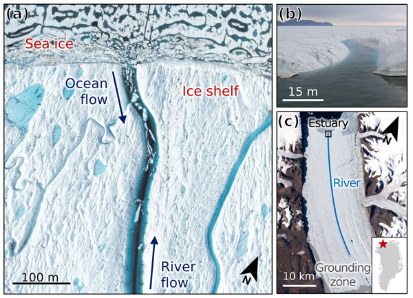
Abstract. Ice shelf rivers may reduce ice shelf instability by exporting surface meltwater from the ice shelf, limiting loading-induced stresses from ponded meltwater. However, if a supraglacial river incises to below sea level, forming an ice-shelf estuary, this mitigating effect may be negated. Water flow reversal in the estuary loads the ice shelf, inducing flexural stress, and prevents efficient meltwater export into the ocean. Evidence of this phenomenon has only been observed on the Petermann Ice Shelf in northern Greenland to date. A key factor in determining when and where ice-shelf estuaries form is river incision rate, defined as the decrease in channel bed elevation over time. Here we present a novel method for calculating incision rate in supraglacial rivers from paired multispectral WorldView-2/3 imagery and corresponding ArcticDEM strips. We apply this method over the Petermann Ice Shelf in 2014 and in 2016. The patterns of incision differ substantially between the two years, with the highest rates of incision occurring near the supraglacial river/estuary mouth in 2014, compared to the lowest incision rates at the same location in 2016. Using high-resolution satellite observations from WorldView imagery from 2013–2018 and modelled runoff, we conclude that the contrasting incision patterns are caused by the formation of the Petermann estuary and resultant water flow reversal, which inhibits efficient meltwater export. This in turn reduces frictional melting of the channel bottom and likely reduces the water surface slope, both of which cause the channel to cease deepening and become broader. Although the estuary appears to first form in August 2014, it is not present early in the 2016 melt season but does develop by early July. Similar observations made in subsequent melt seasons reveal a cyclical pattern whereby the estuary re-forms during each melt season as a result of meltwater and ocean water loading and unloading throughout the season.
-
Notice on discussion status
The requested preprint has a corresponding peer-reviewed final revised paper. You are encouraged to refer to the final revised version.
-
Preprint
(2134 KB)
-
Supplement
(1664 KB)
-
The requested preprint has a corresponding peer-reviewed final revised paper. You are encouraged to refer to the final revised version.
- Preprint
(2134 KB) - Metadata XML
-
Supplement
(1664 KB) - BibTeX
- EndNote
- Final revised paper


Journal article(s) based on this preprint
Interactive discussion
Status: closed
-
RC1: 'Comment on egusphere-2026-1396', Peter Washam, 11 May 2026
-
AC1: 'Reply on RC1', Michela Savignano, 03 Jul 2026
The comment was uploaded in the form of a supplement: https://egusphere.copernicus.org/preprints/2026/egusphere-2026-1396/egusphere-2026-1396-AC1-supplement.pdf
-
AC1: 'Reply on RC1', Michela Savignano, 03 Jul 2026
-
RC2: 'Comment on egusphere-2026-1396', Pete Tuckett, 01 Jun 2026
The comment was uploaded in the form of a supplement: https://egusphere.copernicus.org/preprints/2026/egusphere-2026-1396/egusphere-2026-1396-RC2-supplement.pdf
-
AC2: 'Reply on RC2', Michela Savignano, 03 Jul 2026
The comment was uploaded in the form of a supplement: https://egusphere.copernicus.org/preprints/2026/egusphere-2026-1396/egusphere-2026-1396-AC2-supplement.pdf
-
AC2: 'Reply on RC2', Michela Savignano, 03 Jul 2026
Peer review completion


Interactive discussion
Status: closed
-
RC1: 'Comment on egusphere-2026-1396', Peter Washam, 11 May 2026
-
AC1: 'Reply on RC1', Michela Savignano, 03 Jul 2026
The comment was uploaded in the form of a supplement: https://egusphere.copernicus.org/preprints/2026/egusphere-2026-1396/egusphere-2026-1396-AC1-supplement.pdf
-
AC1: 'Reply on RC1', Michela Savignano, 03 Jul 2026
-
RC2: 'Comment on egusphere-2026-1396', Pete Tuckett, 01 Jun 2026
The comment was uploaded in the form of a supplement: https://egusphere.copernicus.org/preprints/2026/egusphere-2026-1396/egusphere-2026-1396-RC2-supplement.pdf
-
AC2: 'Reply on RC2', Michela Savignano, 03 Jul 2026
The comment was uploaded in the form of a supplement: https://egusphere.copernicus.org/preprints/2026/egusphere-2026-1396/egusphere-2026-1396-AC2-supplement.pdf
-
AC2: 'Reply on RC2', Michela Savignano, 03 Jul 2026
Peer review completion
Journal article(s) based on this preprint
Viewed
| HTML | XML | Total | Supplement | BibTeX | EndNote | |
|---|---|---|---|---|---|---|
| 1,017 | 442 | 86 | 1,545 | 152 | 69 | 81 |
- HTML: 1,017
- PDF: 442
- XML: 86
- Total: 1,545
- Supplement: 152
- BibTeX: 69
- EndNote: 81
Viewed (geographical distribution)
| Country | # | Views | % |
|---|
| Total: | 0 |
| HTML: | 0 |
| PDF: | 0 |
| XML: | 0 |
- 1

Alison F. Banwell
Waleed Abdalati
Robin E. Bell
Alexandra Boghosian
W. Roger Buck
Sarah E. Esenther
Emily Glazer
Adam L. LeWinter
Laurence C. Smith
Leigh A. Stearns
The requested preprint has a corresponding peer-reviewed final revised paper. You are encouraged to refer to the final revised version.
- Preprint
(2134 KB) - Metadata XML
-
Supplement
(1664 KB) - BibTeX
- EndNote
- Final revised paper
see attached file