
the Creative Commons Attribution 4.0 License.
the Creative Commons Attribution 4.0 License.
 | 23 Jan 2026
G&M3D 1.0: an Interactive Framework for 3D Model Construction and Forward Calculation of Potential Fields
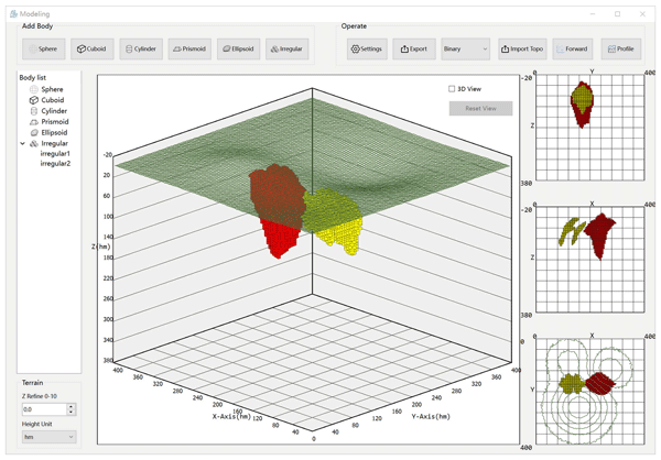
Abstract. Building source models and performing forward calculations are fundamental for processing, analyzing, and interpreting geophysical data. However, there are rare open-source tools available that allow for both the flexible and interactive construction of source models and potential-field forward calculations. To address this gap, we developed a new Qt-based software called G&M3D 1.0, which supports interactive 3D model construction and provides accurate and efficient forward modelling. G&M3D 1.0 features two core functionalities: (1) constructing 3D gravity and magnetic source models and (2) calculating and visualizing their gravity/magnetic fields, as well as their gradient fields. In the 3D Modelling Module, rectangular prisms are used to approximate anomalous geological bodies, striking a balance between computational efficiency and geometric flexibility. Users can conveniently create 3D models with regular shapes, like spheres, cuboids, cylinders, and prismoids, each having variable densities or magnetic parameters. Complex structures can be modelled using the Irregular (Layer-Building) tool, which is especially suitable for stratigraphic or faulted formations. In addition, the Forward-Modelling Module allows for the rapid calculation, visualization, and saving of gravity anomalies, gravity gradients, total magnetic intensity, and magnetic gradients generated by the created 3D sources. To improve the efficiency of the gravity and magnetic forward calculations, the software employs a 2D discrete convolution algorithm. G&M3D 1.0 offers several significant advantages, including open-source accessibility, flexible interactive operations, an intuitive 3D modelling interface, efficient forward computation, and excellent file portability. As a demonstration of its capabilities, we utilized G&M3D 1.0 for forward gravity modelling over a salt dome at Vinton Dome in southern Louisiana, U.S., providing validation of its accuracy and practicality.
-
Notice on discussion status
The requested preprint has a corresponding peer-reviewed final revised paper. You are encouraged to refer to the final revised version.
-
Preprint
(1860 KB)
-
Supplement
(177347 KB)
-
The requested preprint has a corresponding peer-reviewed final revised paper. You are encouraged to refer to the final revised version.
- Preprint
(1860 KB) - Metadata XML
-
Supplement
(177347 KB) - BibTeX
- EndNote
- Final revised paper


Journal article(s) based on this preprint
Interactive discussion
Status: closed
-
RC1: 'Comment on egusphere-2025-5357', Anonymous Referee #1, 09 Feb 2026
-
AC1: 'Reply on RC1', Wang Dengkang, 30 Apr 2026
We sincerely thank the reviewer for the constructive comments. We appreciate the reviewer’s recognition of the relevance of G&M3D 1.0 to the scope of GMD, as well as the clarity of the manuscript and figures. The comments are very helpful for improving the flexibility, computational description, accessibility, and clarity of the software and manuscript. We have carefully revised the manuscript and the repository documentation accordingly. Detailed point-by-point responses are provided in the attached response letter.
-
AC1: 'Reply on RC1', Wang Dengkang, 30 Apr 2026
-
RC2: 'Comment on egusphere-2025-5357', Anonymous Referee #2, 23 Mar 2026
I have read and reviewed the manuscript entitled “G&M3D 1.0: an Interactive Framework for 3D Model Construction and Forward Calculation of Potential Fields.” The paper addresses an important and practical challenge in the potential-field community, namely the construction of realistic and geologically meaningful 3-D synthetic models. From both technical and implementation perspectives, the manuscript is generally well structured and in good shape. I therefore recommend minor revision. My moderate-level comments are listed below.
-Software design philosophy and architectural principles
As the manuscript presents a scientific software framework, it would be beneficial to more clearly describe the underlying software design philosophy and architectural principles adopted in the development of G&M3D. For example, discussing aspects such as modularity, low coupling and high cohesion, extensibility, and the separation between data structures and computational kernels would help readers better understand the robustness, scalability, and long-term maintainability of the framework.
-Input/output specifications and data interoperability
The paper would benefit from a clearer description of input and output requirements. In particular, it would be useful to specify supported data formats, model parameterization conventions (e.g., coordinate systems and right-hand rule definitions. A brief discussion on interoperability with existing modelling or inversion workflows (e.g., UBC-GIF formats, SEG standards, Oasis Montaj, etc) would further enhance the practical value and adoption potential of the framework.
-Representation of heterogeneous physical properties
In the current implementation, each geological body appears to be assigned a constant physical property. The authors are encouraged to discuss the spatially varying physical properties, for example, Gaussian distribution.
Citation: https://doi.org/10.5194/egusphere-2025-5357-RC2 -
AC2: 'Reply on RC2', Wang Dengkang, 30 Apr 2026
We sincerely thank the reviewer for the positive evaluation of our manuscript and for recognizing the practical value of G&M3D 1.0 in constructing realistic and geologically meaningful 3-D synthetic models. We also appreciate the reviewer’s helpful comments on the software design philosophy, input/output specifications, data interoperability, and heterogeneous physical-property representation. These suggestions have helped us improve both the manuscript and the software description. We have revised the manuscript accordingly, and detailed point-by-point responses are provided in the attached response letter.
-
AC2: 'Reply on RC2', Wang Dengkang, 30 Apr 2026


Interactive discussion
Status: closed
-
RC1: 'Comment on egusphere-2025-5357', Anonymous Referee #1, 09 Feb 2026
The manuscript by Wang and co-authors presents G&M3D, a software package with a graphical user interface to create a set of three-dimensional subsurface bodies. The bodies are either based on basic geometric shapes or freely drawn with the mouse on individual profiles and then combined into a 3D volume. The software furthermore allows the user to assign density differences and magnetic properties to the bodies and forward model the resulting gravity anomalies and magnetic intensity as well as their gradients. The authors demonstrate the software’s capabilities in an application to the gravity anomaly caused by a real salt dome. The manuscript is well written, the text is clear in most places, and the content fits the scope of GMD. The Figures nicely illustrate how the graphical user interface looks and can be used.
There are some concerns/open questions regarding the flexibility and efficiency of the method, the accessibility of the software, and the clarity of the text. These can be addressed with moderate revisions. Please see the attached PDF for my comments.-
AC1: 'Reply on RC1', Wang Dengkang, 30 Apr 2026
We sincerely thank the reviewer for the constructive comments. We appreciate the reviewer’s recognition of the relevance of G&M3D 1.0 to the scope of GMD, as well as the clarity of the manuscript and figures. The comments are very helpful for improving the flexibility, computational description, accessibility, and clarity of the software and manuscript. We have carefully revised the manuscript and the repository documentation accordingly. Detailed point-by-point responses are provided in the attached response letter.
-
AC1: 'Reply on RC1', Wang Dengkang, 30 Apr 2026
-
RC2: 'Comment on egusphere-2025-5357', Anonymous Referee #2, 23 Mar 2026
I have read and reviewed the manuscript entitled “G&M3D 1.0: an Interactive Framework for 3D Model Construction and Forward Calculation of Potential Fields.” The paper addresses an important and practical challenge in the potential-field community, namely the construction of realistic and geologically meaningful 3-D synthetic models. From both technical and implementation perspectives, the manuscript is generally well structured and in good shape. I therefore recommend minor revision. My moderate-level comments are listed below.
-Software design philosophy and architectural principles
As the manuscript presents a scientific software framework, it would be beneficial to more clearly describe the underlying software design philosophy and architectural principles adopted in the development of G&M3D. For example, discussing aspects such as modularity, low coupling and high cohesion, extensibility, and the separation between data structures and computational kernels would help readers better understand the robustness, scalability, and long-term maintainability of the framework.
-Input/output specifications and data interoperability
The paper would benefit from a clearer description of input and output requirements. In particular, it would be useful to specify supported data formats, model parameterization conventions (e.g., coordinate systems and right-hand rule definitions. A brief discussion on interoperability with existing modelling or inversion workflows (e.g., UBC-GIF formats, SEG standards, Oasis Montaj, etc) would further enhance the practical value and adoption potential of the framework.
-Representation of heterogeneous physical properties
In the current implementation, each geological body appears to be assigned a constant physical property. The authors are encouraged to discuss the spatially varying physical properties, for example, Gaussian distribution.
Citation: https://doi.org/10.5194/egusphere-2025-5357-RC2 -
AC2: 'Reply on RC2', Wang Dengkang, 30 Apr 2026
We sincerely thank the reviewer for the positive evaluation of our manuscript and for recognizing the practical value of G&M3D 1.0 in constructing realistic and geologically meaningful 3-D synthetic models. We also appreciate the reviewer’s helpful comments on the software design philosophy, input/output specifications, data interoperability, and heterogeneous physical-property representation. These suggestions have helped us improve both the manuscript and the software description. We have revised the manuscript accordingly, and detailed point-by-point responses are provided in the attached response letter.
-
AC2: 'Reply on RC2', Wang Dengkang, 30 Apr 2026
Peer review completion


Journal article(s) based on this preprint
Viewed
| HTML | XML | Total | Supplement | BibTeX | EndNote | |
|---|---|---|---|---|---|---|
| 882 | 637 | 109 | 1,628 | 353 | 95 | 129 |
- HTML: 882
- PDF: 637
- XML: 109
- Total: 1,628
- Supplement: 353
- BibTeX: 95
- EndNote: 129
Viewed (geographical distribution)
| Country | # | Views | % |
|---|
| Total: | 0 |
| HTML: | 0 |
| PDF: | 0 |
| XML: | 0 |
- 1
Dengkang Wang
Kanggui Wei
Jiaxiang Peng
Rongwen Guo
The requested preprint has a corresponding peer-reviewed final revised paper. You are encouraged to refer to the final revised version.
- Preprint
(1860 KB) - Metadata XML
-
Supplement
(177347 KB) - BibTeX
- EndNote
- Final revised paper
The manuscript by Wang and co-authors presents G&M3D, a software package with a graphical user interface to create a set of three-dimensional subsurface bodies. The bodies are either based on basic geometric shapes or freely drawn with the mouse on individual profiles and then combined into a 3D volume. The software furthermore allows the user to assign density differences and magnetic properties to the bodies and forward model the resulting gravity anomalies and magnetic intensity as well as their gradients. The authors demonstrate the software’s capabilities in an application to the gravity anomaly caused by a real salt dome. The manuscript is well written, the text is clear in most places, and the content fits the scope of GMD. The Figures nicely illustrate how the graphical user interface looks and can be used.
There are some concerns/open questions regarding the flexibility and efficiency of the method, the accessibility of the software, and the clarity of the text. These can be addressed with moderate revisions. Please see the attached PDF for my comments.