
the Creative Commons Attribution 4.0 License.
the Creative Commons Attribution 4.0 License.
 | 25 Nov 2025
Assessment of SWOT water surface elevations for flood monitoring of a narrow river (< 50 m width)
Abstract. Floods are among the most frequent and damaging natural hazards worldwide, and reliable observations of water surface elevation (WSE) are essential for improving flood modelling and risk management. The Surface Water and Ocean Topography (SWOT) satellite, launched in 2022, offers new opportunities to monitor river hydrodynamics from space, but its performance in relatively narrow rivers (< 50 m width) remains poorly documented. This study evaluates the potential of SWOT WSEs for flood monitoring by comparing them with in situ observations as well as simulations from an existing large-scale hydraulic model (LISFLOOD-FP) on the Du Gouffre River (width ≈ 40 m), located in Quebec, Canada. The L2_HR_RiverSP (RiverSP) SWOT product Version D, derived from a priori database (SWORD), was first compared with one-minute WSE measurements from a tidal gauge located downstream the Du Gouffre River in the St. Lawrence River. This comparison confirmed the overall quality of the SWOT data in this area, with a root mean square error (RMSE) of 0.24 m. Then, a major flood event (with a return period of about 60 years) which occurred on May 1, 2023, during the SWOT’s calibration orbit, was used to conduct a daily analysis of the entire flood event. Eleven observation cycles, covering the period from April 25 to May 7, 2023, were analysed. Limited ground-based observations were available along the studied reach during the flood, highlighting the value of SWOT data. The 1D/2D hydraulic model LISFLOOD-FP was run for the discharges corresponding to eleven SWOT cycles. Overall, there was good agreement with SWOT WSEs, with biases ranging from -0.30 to 0.44 m and RMSEs between 0.14 and 0.54 m. For the peak-flood cycle (May 1), upstream discharges were initially underestimated, and an adjusted LISFLOOD-FP simulation constrained by SWOT observations resulted in a bias of -0.30 m and an RMSE of 0.54 m. This study confirms that SWOT WSEs can provide relevant hydraulic information during flood events in a river below the mission’s detection limit, thereby opening the way for a broader use in flood monitoring and modelling.
-
Notice on discussion status
The requested preprint has a corresponding peer-reviewed final revised paper. You are encouraged to refer to the final revised version.
-
Preprint
(1303 KB)
-
The requested preprint has a corresponding peer-reviewed final revised paper. You are encouraged to refer to the final revised version.
- Preprint
(1303 KB) - Metadata XML
- BibTeX
- EndNote
- Final revised paper


Journal article(s) based on this preprint
Interactive discussion
Status: closed
-
RC1: 'Comment on egusphere-2025-5449', Anonymous Referee #1, 08 Jan 2026
- AC3: 'Reply on RC1', Amal Mzoughi, 02 Mar 2026
-
RC2: 'Comment on egusphere-2025-5449', Gurjeet Singh, 17 Jan 2026
The manuscript is based on an important and relevant problem by assessing the applicability of SWOT-derived water surface elevations (WSE) for flood monitoring (during the calibration orbit) and hydraulic modeling in rivers narrower than the nominal SWOT detection threshold (< 50 m). The use of an actual extreme flood, rather than simulated SWOT data, is a good approach. Overall, the paper is technically detailed, well referenced, and well written.
However, while the study is a good case study, its scientific novelty and strength of conclusions remain limited. The manuscript demonstrates consistency between SWOT WSE and a pre-existing LISFLOOD-FP model, rather than providing a rigorous, independent assessment of SWOT performance in narrow rivers. As a result, contribution is not significant and shows simply as case study rather than advancing understanding beyond what has already been shown in recent studies, especially for the narrow river (<50 m).
The specific comments are as given below:
- The main conclusion of this study that SWOT WSEs are “sufficiently accurate” for a ~40 m wide river, is already well reported in the recent past studies comparable or better performance for rivers < 50–100 m. However, this manuscript failed to justify what new insight is added beyond confirming prior findings at one site. I suggest authors should critically investigate (1) whether measurements errors are systematic or site-specific, (2) whether performance is robust to geometry, slope, or hydraulic complexity, or (3) whether SWOT observations add information beyond what the hydraulic modelling framework (LISFLOOD-FP) already assumes.
- It looks like the manuscript is the lack of independence between the SWOT observations and data and LISFLOOD-FP model used for evaluation. The LISFLOOD-FP model is based on LiDAR-derived bathymetry and unchanging roughness assumptions, and discharge inputs that are uncertain during the flood peak, and most important issue this model is not calibrated. However, SWOT WSEs are then compared against this model and refereed “accurate” whenever good agreement is found. Additionally, during the flood peak (cycle 508), SWOT is explicitly used to calibrate tributary discharge, after which agreement improves. This creates issue, as SWOT validates a model that is partially constrained or adjusted using SWOT itself. Consequently, the reported RMSE and bias values cannot be interpreted as true SWOT measurement errors.
- The absence of independent, spatially distributed in situ water level data along the studied river reach further lacks sufficient validation. Apart from the downstream tide gauge, no ground-based WSE measurements are available during the flood event, especially along the main channel where SWOT nodes are evaluated. As a result, the performance of SWOT upstream is referred entirely from agreement with the hydraulic model rather than from direct observations. While drone imagery provides useful qualitative confirmation of flood extent, it does not offer independent vertical validation of WSE. This limitation is referred only briefly but should be emphasized more strongly, as it fundamentally constrains the strength of the conclusions regarding SWOT accuracy in narrow rivers.
- The discharge calibration for the Des Mares tributary during the flood peak is presented as a key demonstration of SWOT’s advantage, but I feel it is not sufficiently justified/analyzed to support these strong claims. Authors presented a single calibrated scenario and fail to provide any sensitivity analysis to demonstrate that the improved agreement is exclusively attributable to the adjusted tributary discharge. Other factors, such as roughness values, downstream boundary conditions, or bathymetric uncertainty, could possibly produce similar improvements. As such, the conclusion that SWOT observations reveal discharge underestimation and effectively constrain ungauged tributary inflows is reasonable but not conclusively demonstrated.
- Authors also failed to provide a critical discussion on interpretation of error metrics. In this manuscript RMSE values up to 0.54 m and biases as large as ±0.44 m is described as good agreement, yet these errors are significant relative to flood-stage variations and operational flood-monitoring requirements. Moreover, the manuscript also fails to justify whether these errors are driven primarily by SWOT measurement uncertainty or by hydraulic model limitations. Authors should explore where and why SWOT performs good or poor in a narrow channel, maybe they can explore spatial patterns in error related to channel geometry, curvature, or node averaging effects in a ~40 m wide channel.
- Increase the font size of Figures axis, and legends for ease of readability (e.g., Figure 4, Fig.5).
Citation: https://doi.org/10.5194/egusphere-2025-5449-RC2 - AC2: 'Reply on RC2', Amal Mzoughi, 02 Mar 2026
-
RC3: 'Comment on egusphere-2025-5449', Anonymous Referee #3, 19 Jan 2026
The paper is well written and easy to follow. The use of SWOT calibration-orbit data during a real flood event is a valuable contribution. The comparison with tide gauge data shows good quality of SWOT WSE in this area. Testing SWOT during different flood phases (before, during, and after the peak) is also a strength of this study. However, the study covers only one river and one flood event, and most comparisons are with the hydraulic model rather than independent observations along the reach. I suggest the authors be more careful about broad claims on SWOT performance in rivers <50 m.
[Lines 27–28, 271–273] The abstract and discussion suggest the results apply broadly to narrow rivers, but the study only covers one ~40 m river and one flood. I suggest the authors clearly state that these findings are specific to this site and event.
[Lines 238–243, 290–295] For cycle 508, the authors adjusted the model discharge using SWOT data and then compared the model back to SWOT. I have two concerns: (a) please report bias and RMSE both before and after the adjustment, and (b) please clarify that this comparison shows model-SWOT consistency, not independent validation of SWOT accuracy.
[Lines 23–25, 271–273] The authors describe bias up to 0.44 m and RMSE up to 0.54 m as "good agreement" and "satisfactory accuracy," but do not justify why. Whether these errors are acceptable depends on the WSE amplitude during the flood. I suggest the authors discuss the error magnitude relative to the flood signal (for example, RMSE as a percentage of WSE range) to support these claims.
[Lines 195–198] Some nodes were removed manually, but the criteria are not clear. I suggest the authors (a) define objective rules for removal, (b) report how many nodes were removed per cycle, and (c) test how sensitive the results are to this step.
[Figure 5] I find it hard to tell the two groups apart. I suggest using different line styles or separate panels.
Citation: https://doi.org/10.5194/egusphere-2025-5449-RC3 - AC1: 'Reply on RC3', Amal Mzoughi, 02 Mar 2026
-
EC1: 'Comment on egusphere-2025-5449', Narendra Das, 22 Jan 2026
Based on the comments provided by the Reviewers, I would recommend the authors to prepare for the revision of the manuscript.
Citation: https://doi.org/10.5194/egusphere-2025-5449-EC1
Peer review completion


Interactive discussion
Status: closed
-
RC1: 'Comment on egusphere-2025-5449', Anonymous Referee #1, 08 Jan 2026
This paper is generally well written on assessing the performance of SWOT measurement of surface water equivalent (WSE) over a narrow river during a flood event. The study first compared SWOT measurement with a tide gauge and obtained good results, suggesting SWOT is meeting mission requirement even for rivers with width less than 50 m. SWOT data over the studied river were then compared with model simulations. The close agreement of the comparison has validated the model and demonstrated the utility of SWOT in flood monitoring and modeling.
I recommend the paper be published with the following comments for the authors to consider for a revision.
Lines 74-82: The discussions on the performance of SWOT from various sources need to be summarized in a coherent manner. There are three scales involved: a global assessment of 0.15 m (Yu et al,2024); a regional assessment of 0.25 m (Jiang et al 2025), and a subcontinental (over India) assessment of 18 cm (Patidar et al 2025). The latter two are for narrow rivers, but the first seems to be for all rivers. I think these results need to be discussed in the context of spatial scales versus the mission requirement.
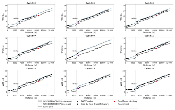
Lines 219-223: The discussion here is very confusing. On Fig 4, I don’t find the information on probability, the 68th percentile is 0.05 m, RMSE 0f 0.24 m? Something is missing on Fig 4, which shows only the comparison of WSE from SWOT with model simulations.
Lastly, I would suggest that all the figure captions be more elaborate with some details.
Citation: https://doi.org/10.5194/egusphere-2025-5449-RC1 - AC3: 'Reply on RC1', Amal Mzoughi, 02 Mar 2026
-
RC2: 'Comment on egusphere-2025-5449', Gurjeet Singh, 17 Jan 2026
The manuscript is based on an important and relevant problem by assessing the applicability of SWOT-derived water surface elevations (WSE) for flood monitoring (during the calibration orbit) and hydraulic modeling in rivers narrower than the nominal SWOT detection threshold (< 50 m). The use of an actual extreme flood, rather than simulated SWOT data, is a good approach. Overall, the paper is technically detailed, well referenced, and well written.
However, while the study is a good case study, its scientific novelty and strength of conclusions remain limited. The manuscript demonstrates consistency between SWOT WSE and a pre-existing LISFLOOD-FP model, rather than providing a rigorous, independent assessment of SWOT performance in narrow rivers. As a result, contribution is not significant and shows simply as case study rather than advancing understanding beyond what has already been shown in recent studies, especially for the narrow river (<50 m).
The specific comments are as given below:
- The main conclusion of this study that SWOT WSEs are “sufficiently accurate” for a ~40 m wide river, is already well reported in the recent past studies comparable or better performance for rivers < 50–100 m. However, this manuscript failed to justify what new insight is added beyond confirming prior findings at one site. I suggest authors should critically investigate (1) whether measurements errors are systematic or site-specific, (2) whether performance is robust to geometry, slope, or hydraulic complexity, or (3) whether SWOT observations add information beyond what the hydraulic modelling framework (LISFLOOD-FP) already assumes.
- It looks like the manuscript is the lack of independence between the SWOT observations and data and LISFLOOD-FP model used for evaluation. The LISFLOOD-FP model is based on LiDAR-derived bathymetry and unchanging roughness assumptions, and discharge inputs that are uncertain during the flood peak, and most important issue this model is not calibrated. However, SWOT WSEs are then compared against this model and refereed “accurate” whenever good agreement is found. Additionally, during the flood peak (cycle 508), SWOT is explicitly used to calibrate tributary discharge, after which agreement improves. This creates issue, as SWOT validates a model that is partially constrained or adjusted using SWOT itself. Consequently, the reported RMSE and bias values cannot be interpreted as true SWOT measurement errors.
- The absence of independent, spatially distributed in situ water level data along the studied river reach further lacks sufficient validation. Apart from the downstream tide gauge, no ground-based WSE measurements are available during the flood event, especially along the main channel where SWOT nodes are evaluated. As a result, the performance of SWOT upstream is referred entirely from agreement with the hydraulic model rather than from direct observations. While drone imagery provides useful qualitative confirmation of flood extent, it does not offer independent vertical validation of WSE. This limitation is referred only briefly but should be emphasized more strongly, as it fundamentally constrains the strength of the conclusions regarding SWOT accuracy in narrow rivers.
- The discharge calibration for the Des Mares tributary during the flood peak is presented as a key demonstration of SWOT’s advantage, but I feel it is not sufficiently justified/analyzed to support these strong claims. Authors presented a single calibrated scenario and fail to provide any sensitivity analysis to demonstrate that the improved agreement is exclusively attributable to the adjusted tributary discharge. Other factors, such as roughness values, downstream boundary conditions, or bathymetric uncertainty, could possibly produce similar improvements. As such, the conclusion that SWOT observations reveal discharge underestimation and effectively constrain ungauged tributary inflows is reasonable but not conclusively demonstrated.
- Authors also failed to provide a critical discussion on interpretation of error metrics. In this manuscript RMSE values up to 0.54 m and biases as large as ±0.44 m is described as good agreement, yet these errors are significant relative to flood-stage variations and operational flood-monitoring requirements. Moreover, the manuscript also fails to justify whether these errors are driven primarily by SWOT measurement uncertainty or by hydraulic model limitations. Authors should explore where and why SWOT performs good or poor in a narrow channel, maybe they can explore spatial patterns in error related to channel geometry, curvature, or node averaging effects in a ~40 m wide channel.
- Increase the font size of Figures axis, and legends for ease of readability (e.g., Figure 4, Fig.5).
Citation: https://doi.org/10.5194/egusphere-2025-5449-RC2 - AC2: 'Reply on RC2', Amal Mzoughi, 02 Mar 2026
-
RC3: 'Comment on egusphere-2025-5449', Anonymous Referee #3, 19 Jan 2026
The paper is well written and easy to follow. The use of SWOT calibration-orbit data during a real flood event is a valuable contribution. The comparison with tide gauge data shows good quality of SWOT WSE in this area. Testing SWOT during different flood phases (before, during, and after the peak) is also a strength of this study. However, the study covers only one river and one flood event, and most comparisons are with the hydraulic model rather than independent observations along the reach. I suggest the authors be more careful about broad claims on SWOT performance in rivers <50 m.
[Lines 27–28, 271–273] The abstract and discussion suggest the results apply broadly to narrow rivers, but the study only covers one ~40 m river and one flood. I suggest the authors clearly state that these findings are specific to this site and event.
[Lines 238–243, 290–295] For cycle 508, the authors adjusted the model discharge using SWOT data and then compared the model back to SWOT. I have two concerns: (a) please report bias and RMSE both before and after the adjustment, and (b) please clarify that this comparison shows model-SWOT consistency, not independent validation of SWOT accuracy.
[Lines 23–25, 271–273] The authors describe bias up to 0.44 m and RMSE up to 0.54 m as "good agreement" and "satisfactory accuracy," but do not justify why. Whether these errors are acceptable depends on the WSE amplitude during the flood. I suggest the authors discuss the error magnitude relative to the flood signal (for example, RMSE as a percentage of WSE range) to support these claims.
[Lines 195–198] Some nodes were removed manually, but the criteria are not clear. I suggest the authors (a) define objective rules for removal, (b) report how many nodes were removed per cycle, and (c) test how sensitive the results are to this step.
[Figure 5] I find it hard to tell the two groups apart. I suggest using different line styles or separate panels.
Citation: https://doi.org/10.5194/egusphere-2025-5449-RC3 - AC1: 'Reply on RC3', Amal Mzoughi, 02 Mar 2026
-
EC1: 'Comment on egusphere-2025-5449', Narendra Das, 22 Jan 2026
Based on the comments provided by the Reviewers, I would recommend the authors to prepare for the revision of the manuscript.
Citation: https://doi.org/10.5194/egusphere-2025-5449-EC1
Peer review completion
Journal article(s) based on this preprint
Viewed
| HTML | XML | Total | BibTeX | EndNote | |
|---|---|---|---|---|---|
| 2,420 | 2,165 | 139 | 4,724 | 1,320 | 671 |
- HTML: 2,420
- PDF: 2,165
- XML: 139
- Total: 4,724
- BibTeX: 1,320
- EndNote: 671
Viewed (geographical distribution)
| Country | # | Views | % |
|---|
| Total: | 0 |
| HTML: | 0 |
| PDF: | 0 |
| XML: | 0 |
- 1
Amal Mzoughi

Mélanie Trudel
Pascale Biron
Guénolé Choné
Gabriela Llanet Siles
The requested preprint has a corresponding peer-reviewed final revised paper. You are encouraged to refer to the final revised version.
- Preprint
(1303 KB) - Metadata XML
This paper is generally well written on assessing the performance of SWOT measurement of surface water equivalent (WSE) over a narrow river during a flood event. The study first compared SWOT measurement with a tide gauge and obtained good results, suggesting SWOT is meeting mission requirement even for rivers with width less than 50 m. SWOT data over the studied river were then compared with model simulations. The close agreement of the comparison has validated the model and demonstrated the utility of SWOT in flood monitoring and modeling.
I recommend the paper be published with the following comments for the authors to consider for a revision.
Lines 74-82: The discussions on the performance of SWOT from various sources need to be summarized in a coherent manner. There are three scales involved: a global assessment of 0.15 m (Yu et al,2024); a regional assessment of 0.25 m (Jiang et al 2025), and a subcontinental (over India) assessment of 18 cm (Patidar et al 2025). The latter two are for narrow rivers, but the first seems to be for all rivers. I think these results need to be discussed in the context of spatial scales versus the mission requirement.
Lines 219-223: The discussion here is very confusing. On Fig 4, I don’t find the information on probability, the 68th percentile is 0.05 m, RMSE 0f 0.24 m? Something is missing on Fig 4, which shows only the comparison of WSE from SWOT with model simulations.
Lastly, I would suggest that all the figure captions be more elaborate with some details.