
the Creative Commons Attribution 4.0 License.
the Creative Commons Attribution 4.0 License.
 | 18 Sep 2025
Integrating Topographic Continuity and Lake Recession Dynamics for Improved Bathymetry Mapping from DEMs
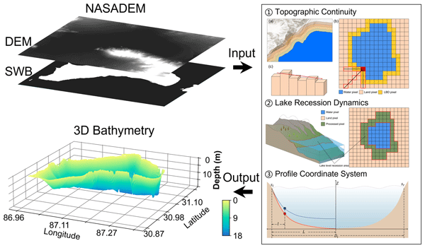
Abstract. Accurate lake bathymetry is critical for advancing hydrological and biogeochemical research, yet large-scale and deep-water mapping remains constrained by cost challenges. While remote sensing techniques have been extensively employed for bathymetry mapping, their effectiveness is primarily limited to shallow waters due to the rapid attenuation of optical signals with increasing depth. To overcome this limitation, we propose a novel bathymetry mapping method that leverages topographic continuity to infer underwater terrain by simulating lake level recession dynamics. This approach relies solely on Digital Elevation Model (DEM) data, using shoreline topographic gradients to estimate depth, providing a robust alternative for regions where conventional surveying is impractical. Validation across 12 lakes on the Tibetan Plateau demonstrated promising accuracy, with an average normalized root mean square error of 19.08 % for depth estimation and a mean absolute percentage error of 23.47 % for lake volume. To evaluate the method’s generalizability across diverse hydrological settings, it was applied to Lake Mead, United States, producing a bathymetry map with a correlation coefficient of 0.66 against in situ measurements. Overall, this study introduces a low-cost solution for bathymetry mapping in data-scarce regions, offering a valuable tool for assessing lake volume at regional and global scales.
-
Notice on discussion status
The requested preprint has a corresponding peer-reviewed final revised paper. You are encouraged to refer to the final revised version.
-
Preprint
(2425 KB)
-
Supplement
(399 KB)
-
The requested preprint has a corresponding peer-reviewed final revised paper. You are encouraged to refer to the final revised version.
- Preprint
(2425 KB) - Metadata XML
-
Supplement
(399 KB) - BibTeX
- EndNote
- Final revised paper


Journal article(s) based on this preprint
Interactive discussion
Status: closed
-
RC1: 'Comment on egusphere-2025-4180', Anonymous Referee #1, 11 Oct 2025
-
AC1: 'Reply on RC1', Yao Li, 05 Jan 2026
The comment was uploaded in the form of a supplement: https://egusphere.copernicus.org/preprints/2025/egusphere-2025-4180/egusphere-2025-4180-AC1-supplement.pdf
-
AC1: 'Reply on RC1', Yao Li, 05 Jan 2026
-
RC2: 'Comment on egusphere-2025-4180', Anonymous Referee #2, 08 Dec 2025
This manuscript presents a promising and innovative framework for reconstructing lake bathymetry by leveraging topographic continuity and widely available Digital Elevation Models (DEMs). The study addresses a critical need for cost-effective alternatives to traditional surveys, and the validation effort involving 12 lakes on the Tibetan Plateau represents a substantial and valuable contribution to the field. While the work is well-structured and tackles a clearly defined problem, the manuscript would benefit from the following refinements to further strengthen its theoretical grounding and clarify its methodological contributions.
- The manuscript’s conceptual framing could be significantly strengthened by realigning the "lake recession" terminology with the well-documented hydrological expansion of lakes on the Tibetan Plateau.
- Reframing the method’s success as leveraging "historical exposure" captured in older DEMs (e.g., SRTM 2000) prior to inundation would better articulate the physical mechanism driving the accurate results.
- In order to enhance the study’s robustness, it would be beneficial to elaborate on the rationale for selecting the 12 validation lakes. For instance, classifying these lakes by geomorphological origin (e.g., tectonic, glacial) and discussing the algorithm’s consistency across these types would greatly increase the paper’s utility for the broader research community.
- It is suggested to include a sensitivity analysis regarding the width of the "dynamic exposed area" used for slope calculation in Discussions.
- For the proposed Method, it would be better to suggest a recommended threshold for this exposed zone would provide valuable guidance for users applying this method to lakes with varying bank steepness.
- The error analysis would be more impactful if it moved beyond listing discrepancies to offering a geomorphological diagnosis of the results. Explicitly linking performance variations (e.g., in Dongcuo and Ngangla Ringco) to factors such as signal-to-noise ratios or structural decoupling would add significant depth to the findings.
- The discussion in Section 4.2 regarding the performance of NASADEM versus ALOS PALSAR offers an opportunity for deeper insight. Highlighting the temporal advantage of the older NASADEM (acquired during low stands) rather than focusing solely on spatial resolution would provide a compelling explanation for its superior performance.
- Abstract: A minor adjustment to punctuation in the phrase "Bathymetry data and lake volume two key physical parameters" is recommended.
- Section 1: To correct the typo in the header "Introdution".
Citation: https://doi.org/10.5194/egusphere-2025-4180-RC2 -
AC2: 'Reply on RC2', Yao Li, 05 Jan 2026
The comment was uploaded in the form of a supplement: https://egusphere.copernicus.org/preprints/2025/egusphere-2025-4180/egusphere-2025-4180-AC2-supplement.pdf
Peer review completion


Interactive discussion
Status: closed
-
RC1: 'Comment on egusphere-2025-4180', Anonymous Referee #1, 11 Oct 2025
This study is interesting, lake water storage and water depth estimation is important for water resources research, but it is also difficult to get the high accuracy water depth except in situ measurement. This study provided a method to estimate the water depth using the topography similarity, but this method also has a large error comparing with in situ bathymetric data. I suggest that this manuscript need a major revision, and the primary comments as followed.
- Line 75, Figure 7 shows a large difference between simulate water depth and in situ water depth with a large uncertainty, and the ratio of sediment accumulation is slow, but the authors said that this approach provides a more accurate representation of underwater topography, I had a doubt about it.
- Line 75, actually, the similar method had been used in Fang et al. (2023), what the difference between this study and Fang et al. (2023), and point out the real novel of this study.
- Line 105, how did you get the lake boundary? From the results of interpolation? Why did you get the lake boundary from Landsat image, which the time of Landsat is consistent with the measured time of these in situ data.
- Table 1, suggest to add the measured date, because the water depth of these lakes is changing in recent years
- Why did the author select a USA lake, and an artificial reservoir to assess the method’s applicability? Maybe the reservoir had a large different with natural lakes, especially for Tibetan Plateau.
- Figure 7, whether the authors could redraw this figure with density of these points for different color. Besides, the error of this method for many points is too large, so that I doubt whether this method could provide a more accuracy water depth for water storage estimation or other research. For instance, for a lake, parts of these water depth are overestimation, and parts of these water depth are underestimation, leading to a high accuracy of water storage estimation comparing with in situ bathymetric data, therefore, whether this method is meaningful?
- Table 2, whether the maximum depth for one lake is located in same location between in situ bathymetric data and simulated water depth?
- If all simulated points also had a large error, I doubt that the water storage estimation is not meaningful. For instance, Taro Co, the error of many points is large than 50% or 100%, therefore, whether the authors think that the results of water depth will affect the results of water storage estimation.
- I suggest that the elevation profiles for each lakes should marked in Figure 1.
- Figure 11, the error for Mead lake is also large, many points are underestimation or overestimation. I also think that the accuracy of water depth is much more important than that of water storage estimation.
Citation: https://doi.org/10.5194/egusphere-2025-4180-RC1 -
AC1: 'Reply on RC1', Yao Li, 05 Jan 2026
The comment was uploaded in the form of a supplement: https://egusphere.copernicus.org/preprints/2025/egusphere-2025-4180/egusphere-2025-4180-AC1-supplement.pdf
-
RC2: 'Comment on egusphere-2025-4180', Anonymous Referee #2, 08 Dec 2025
This manuscript presents a promising and innovative framework for reconstructing lake bathymetry by leveraging topographic continuity and widely available Digital Elevation Models (DEMs). The study addresses a critical need for cost-effective alternatives to traditional surveys, and the validation effort involving 12 lakes on the Tibetan Plateau represents a substantial and valuable contribution to the field. While the work is well-structured and tackles a clearly defined problem, the manuscript would benefit from the following refinements to further strengthen its theoretical grounding and clarify its methodological contributions.
- The manuscript’s conceptual framing could be significantly strengthened by realigning the "lake recession" terminology with the well-documented hydrological expansion of lakes on the Tibetan Plateau.
- Reframing the method’s success as leveraging "historical exposure" captured in older DEMs (e.g., SRTM 2000) prior to inundation would better articulate the physical mechanism driving the accurate results.
- In order to enhance the study’s robustness, it would be beneficial to elaborate on the rationale for selecting the 12 validation lakes. For instance, classifying these lakes by geomorphological origin (e.g., tectonic, glacial) and discussing the algorithm’s consistency across these types would greatly increase the paper’s utility for the broader research community.
- It is suggested to include a sensitivity analysis regarding the width of the "dynamic exposed area" used for slope calculation in Discussions.
- For the proposed Method, it would be better to suggest a recommended threshold for this exposed zone would provide valuable guidance for users applying this method to lakes with varying bank steepness.
- The error analysis would be more impactful if it moved beyond listing discrepancies to offering a geomorphological diagnosis of the results. Explicitly linking performance variations (e.g., in Dongcuo and Ngangla Ringco) to factors such as signal-to-noise ratios or structural decoupling would add significant depth to the findings.
- The discussion in Section 4.2 regarding the performance of NASADEM versus ALOS PALSAR offers an opportunity for deeper insight. Highlighting the temporal advantage of the older NASADEM (acquired during low stands) rather than focusing solely on spatial resolution would provide a compelling explanation for its superior performance.
- Abstract: A minor adjustment to punctuation in the phrase "Bathymetry data and lake volume two key physical parameters" is recommended.
- Section 1: To correct the typo in the header "Introdution".
Citation: https://doi.org/10.5194/egusphere-2025-4180-RC2 -
AC2: 'Reply on RC2', Yao Li, 05 Jan 2026
The comment was uploaded in the form of a supplement: https://egusphere.copernicus.org/preprints/2025/egusphere-2025-4180/egusphere-2025-4180-AC2-supplement.pdf
Peer review completion
Journal article(s) based on this preprint
Viewed
| HTML | XML | Total | Supplement | BibTeX | EndNote | |
|---|---|---|---|---|---|---|
| 8,210 | 1,354 | 165 | 9,729 | 465 | 140 | 165 |
- HTML: 8,210
- PDF: 1,354
- XML: 165
- Total: 9,729
- Supplement: 465
- BibTeX: 140
- EndNote: 165
Viewed (geographical distribution)
| Country | # | Views | % |
|---|
| Total: | 0 |
| HTML: | 0 |
| PDF: | 0 |
| XML: | 0 |
- 1
Fukun Tao
Yong Wang
Yinghong Jing
Xiaojun She
Shanlong Lu

The requested preprint has a corresponding peer-reviewed final revised paper. You are encouraged to refer to the final revised version.
- Preprint
(2425 KB) - Metadata XML
-
Supplement
(399 KB) - BibTeX
- EndNote
- Final revised paper
This study is interesting, lake water storage and water depth estimation is important for water resources research, but it is also difficult to get the high accuracy water depth except in situ measurement. This study provided a method to estimate the water depth using the topography similarity, but this method also has a large error comparing with in situ bathymetric data. I suggest that this manuscript need a major revision, and the primary comments as followed.