
the Creative Commons Attribution 4.0 License.
the Creative Commons Attribution 4.0 License.
 | 08 May 2026
Measurement report: Global Total Ozone Records – part 1: ground-based monitoring networks performance assessment and status review
Abstract. Total column ozone (TCO) has been observed since the 1920s, with global monitoring established during the International Geophysical Year (1957–1958). We compile and assess TCO records from six major ground-based instrument types: Dobson and Brewer spectrophotometers, Filter ozonometers, zenith-sky DOAS (UVVIS), Fourier-transform infrared (FTIR) spectroscopy, and Pandora spectrometers. Data are drawn from the World Ozone and Ultraviolet Radiation Data Centre, Network for the Detection of Atmospheric Composition Change, Pandonia Global Network, and European Brewer Network. Using harmonized statistical criteria and daily comparisons with multiple satellite products and four reanalysis datasets, we evaluate site-level performance in five-year intervals from 1940 to 2024. Metrics include mean bias, variability of daily and monthly differences, seasonal amplitude, and the range of annual means, with percentile-based thresholds used to classify data quality.
Ground-based annual means generally agree with satellite and reanalysis benchmarks within ±2 %, with typical variability near 2 %. Larger discrepancies occur in the pre-satellite era, where reanalyses show biases of up to −5 % relative to Dobson observations. Network-wide distributions of daily mean differences indicate comparable internal consistency for Brewer and Pandora (standard deviations generally <2 %), while Filter, FTIR and UVVIS exhibit slightly broader spreads (<3 %), especially at high latitudes.
Network capacity has evolved substantially since the 2000s, with a decline in Dobson sites and expansion of Brewer and Pandora observations. By providing station-level flags and thresholds, this assessment helps users identify robust records, prioritize calibration and reprocessing, which ultimately strengthens their confidence in long-term ozone trend detection and satellite validation.
Competing interests: At least one of the (co-)authors is a member of the editorial board of Atmospheric Chemistry and Physics.
Publisher's note: Copernicus Publications remains neutral with regard to jurisdictional claims made in the text, published maps, institutional affiliations, or any other geographical representation in this paper. While Copernicus Publications makes every effort to include appropriate place names, the final responsibility lies with the authors. Views expressed in the text are those of the authors and do not necessarily reflect the views of the publisher.-
Notice on discussion status
The requested preprint has a corresponding peer-reviewed final revised paper. You are encouraged to refer to the final revised version.
-
Preprint
(5669 KB)
-
The requested preprint has a corresponding peer-reviewed final revised paper. You are encouraged to refer to the final revised version.
- Preprint
(5669 KB) - Metadata XML
- BibTeX
- EndNote
- Final revised paper


Journal article(s) based on this preprint
Interactive discussion
Status: closed
-
RC1: 'Comment on egusphere-2026-2009', Anonymous Referee #1, 12 Jun 2026
- AC1: 'Reply on RC1', Xiaoyi Zhao, 07 Aug 2026
-
RC2: 'Comment on egusphere-2026-2009', Anonymous Referee #2, 22 Jun 2026
Review of Zhao et al. " Measurement report: Global Total Ozone Records – part 1: ground-based monitoring networks performance assessment and status review"
General comments
The manuscript provides a very welcome survey and assessment of the current and historical global ground-based total column ozone observing system. In fact the survey itself would be worth publishing in my opinion even without the quality assessment.
Building on techniques previously used in older work by Fiolotev et al., five different instrument networks (Brewer, Dobson, Filter, FTIR, UV/Vis and Pandora) are compared to multiple satellite sensors and also reanalysis datasets. Such a comprehensive approach is very strongly commended.
I believe the work to be a valuable contribution and worth of publication once some issues below have been considered, which are mostly to do with the presentation and fairly easily addressed.
Specific comments
My first comment is a purely pragmatic one but is crucial. Many readers will only look at figures 6 to 11, which together form the main result of the manuscript. These figures need to make much more obvious that the quality criteria have been tuned separately for each network. This needs to be made clear in the caption of each figure and also the heading for each plot. The captions at the moment say "Same as … " but this is not actually correct.
Secondly, in general the text needs to include more explanation. Several points need more explicit treatment, and some details are skipped over. (I felt when reading the manuscript that the authors seemed to be in too much of a rush to get to the results).
The whole approach relies on assumptions which are never clearly stated. Satellite total ozone datasets have been extensively validated with ground observations and are frequently reprocessed with corrections which may be latitude or zenith angle dependent. They are also extensively compared with each other. At times though the discussion here implies that satellite observations can serve as independent reference data for ground measurements. Presumably the assumption is along the lines that departures from the general pattern of relation between stations and a given instrument indicate a problem with the station, but changes in the general pattern indicate a problem with the satellite? (As is evident in Figure 2 for example). It is clear from figures such as Figure 2 and Figure A1 that the satellites and reanalyses only agree with each other to within a broad band of roughly plus or minus 2%. This must put a limit on your approach.
The value of reanalysis data also is not made out (other than just convenience). The authors need to explain what is the benefit of reanalysis when the satellite overpasses are available from the satellites that have been assimilated.
I am especially unconvinced about the validity of using reanalysis prior to reliable satellite total ozone data. The onus is on the authors to explain why this is valid.
Many of the plots are too cluttered and it is difficult to discern a clear message from them (Figures 1 and 2 in particular are very cluttered and figure 5 could be improved).
The details of the quality tests are referred to but never explained systematically. In particular there is only scattered comments about what the tests are really looking for and how they are assessed (eg lines 88-89). Taking for example, the amplitude of the seasonal component of the difference, I would expect that a given instrument type at a certain latitude compared to a given satellite instrument would have an expected seasonal cycle of differences due to differences in the respective retrievals. You need to explain clearly how you then turn this into a quality check. I would suggest that, at least in the supplement, you plot an example of each of these tests to help the reader understand what their purpose is.
Similarly the method of combining all the satellite instruments together is not explained.
I appreciate that the current work is seen as an update to the older Fioletov papers but even so it needs to be reasonably self-contained and the reader shouldn't have to read the earlier work to understand the details of your approach.
(I am also mildly curious about the fact that no Chinese satellite total ozone datasets have been included?)
Line 26 "global monitoring" – perhaps "systematic" is more the point you're trying to make, rather than "global"? The first sites were distributed in different places around the world, and arguably we still don't have a "global" network.
Lines 41-43 I found this sentence confusing, who is "they"? Do you mean users of the data or operators of the ground sites?
Line 67 "reference network" needs defining – why exactly do you call Brewers "reference" but not Pandoras?
Line 69 "excellent spatial coverage and redundancy" – I can see a lot of white space in the lower panel of figure 1. How do you know that the spatial coverage and redundancy is sufficient outside of western Europe?
Line 78 "networks have expanded or emerged" - Dobsons and Brewers have decreased though.
Lines 78-79 This sentence doesn't make sense to me – how can the networks "offer a more comprehensive" evaluation of themselves?
Lines 103-104 This sentence seems over-stated. "Quality assured" and "traceable" have specific meanings in measurement which don't apply here.
Figure 1 – This figure is much too cluttered and I would say needs a complete redesign. It's very hard to see anything clearly or draw any sort of message from it. I leave this to the authors, but perhaps one suggestion would be to include six panels for the six instrument types.
Line 130 Why do you say "one of "? What would beat it?
Line 132 I suggest adding some words to this sentence making clearer that the stations are frequently calibrated by the regional standard instruments and not necessarily the world standard. The later wording in lines 141-142 is about Brewers.
Line 152-154 It's great that you found this problem and it was able to be corrected.
Lines 155-156 This paragraph reads a little bit strangely to me. It starts talking about UV/Vis in general but then some descriptions of the SAOZ specifically looks like it has been pasted in which is not totally relevant. For example, the abbreviation "CDP" isn't used again .
Line 169 Is this figure for SAOZ specifically? I believe the SAOZ instrument has changed over the years (mini-SAOZ).
Lines 177-178 "As expected" – is the implication then that instruments measuring in the UV are better?
Lines 156, 171, 185 What is the message you are wanting to convey by listing out the different species able to be measured? Is it that only the Dobson and Brewer were specifically designed to measure ozone? Does the order of the lists matter, meaning does it relate to the priority of the design?
Line 189 Where does the 1% figure come from?
Lines 190-191 "Upcoming versions … will address" - it would be more factual to say "are planned to " rather than "will", or "planned upcoming versions" or words to that effect – this all might never happen.
Lines 193-201 You need to give details of the overpass criteria that you've used. Are they consistent for all of these numerous instruments? You don't say anything here about drifts or about changes in crossing times.
Lines 212-213 I can't understand what this sentence means. It doesn't sound like the ozone value can be considered in any way reliable.
Lines 221-222 Why is this relevant?
Lines 225 How is the bias correction done, are the satellite values corrected to match ground observations?
Lines 226-227 Again, this is difficult to make sense of, but it sounds like the pre-satellite ozone values shouldn't be used in the way you're using them?
Lines 232-235 If the satellite data is corrected in this way, can it still be used to assess ground data? In the pre-1979 era the Dobson network was very sparse in many parts of the world.
Lines 243-244 Are you using daily averages for all ground-based data? (It seems to say so a few lines later but it would be clearer to state it here.) Did you consider finer temporal resolutions where it was available?
Line 249 This seems an important point in your analysis but it's rushed over. From what you're saying, the percentiles used later on are calculated with bad data already excluded? Doesn't this affect the use you make of the percentiles later on? (For example, being outside of the 90th percentile range is not so worrying if the 90th percentile is based on only good data). This should be explained. How did you identify the "low quality" data at this stage?
Lines 246-250 You've defined the daily difference but none of the other statistics. It's not sufficient to refer back to Fioletov et al. (1999).
Line 261 Define 'median difference' – do you average each station for a year and then take the median of all the different stations? Or is it the median of all station days? Or something else?
Line 269 Again, interquartile range of what exactly? Stations' daily differences?
Lines 272-274 This seems like an important point but it is skipped over and hard to follow.
Figure 2 – I find the figure much too cluttered. What is the message here? The overall agreement seems very good when completely averaged out but if the satellites have been reprocessed to match the ground networks and each other it's not so surprising.
Line 283-285 Doesn't it call into question the appropriateness of using reanalysis before the modern satellites were operational?
Lines 286-296 A lot of this repeats what has already been said earlier (lines 175-184).
Lines 304-306 Again, some of the different tests are listed ("such as … ") but none of them are ever concretely defined, or their purpose explained.
Lines 338-345 This section is very good but I would like to see it expanded and some plots be included to illustrate what the tests are showing.
Line 356 I can't see that the threshold criteria were defined in section 3.2.
Line 370 "models" – what do you mean here by "model"?
Lines 388-391 When you're counting up these issues, do you count "satellites" as just one, or is each specific sensor counted?
Lines 401-403 It seems to me using NASA AVDC is a great convenience but it does leave you at their mercy if they haven't included a site or have the wrong position for it (as you mention again in line 516). Did you ask them for the missing sites? "Reprocessing" is not the right word here, you would only be extracting overpass values from gridded data.
Figure 5 I can't say I like this figure very much at all. What most stands out to the eye is the solid bar. The different rows are too hard to compare. I suggest a redesign.
Line 424 "trace" – I don't know what you mean by "trace" here? Do you mean just "date", or do you need to uncover them somehow?
Line 426 IGY not IPY and 1957-1958.
Line 439 I don't think you really mean "assured" here. Quality Assurance has a definition. GAW has a Quality Assurance system, eg Quality Assurance
Line 440 What is the advantage of using five year bins?
Line 458 Do you mean "models" here, rather than "reanalyses"?
Line 483 "stronger" should be "greater" or just "larger"
Figure 8 Why don't the stations "SIN", "NAT', "BBN" and "HBT" have actual names? Are these Eubrewnet identifiers? You should give the place-name as well to help the reader.
Figure 8 caption – you can't say "same as" because the criteria for green is different.
Lines 505-511 The discussion repeats what has already been said previously, but I think the more important thing is that the figures need to make clear that the criteria for each network are different, for someone who only looks at the figures and doesn't read all the text. The captions needs to make this explicit.
Line 516 I hope you checked the others. It's disappointing that the mistakes were there but good that you found them.
Lines 518-519 I don't follow the logic of the sentence. Newer sites have not been included in AVDC. Isn't the problem that you are relying on an overpass service that (I believe) isn't being maintained anymore. It's not an issue of satellites per se.
Figure C1 I can't see any the circles or crosses other than in the first panel? It is hard to take a clear message from this figure.
Technical corrections
Line 129 Insert "The" before "Dobson network"
Line 134 Insert "the" before "1970s".
Line 136 Insert "the" before "Brewer"
Line 175 "since many years" – please reword
Line 230 Insert "a" before Kalman
Line 264 Reword "have been found suffering from"
Line 283 "glitches" – please change to a different word, perhaps "discontinuities"
Line 286 – "spectra" should be "spectral"
Line 311 "but not included in this work" shouldn't be in brackets
Line 324 Delete "were" before "changed"
Line 437 Insert "the" before "Dark green"
Line 438 Insert "a" before "Red".
Line 550 "decent" is not the right word here
Citation: https://doi.org/10.5194/egusphere-2026-2009-RC2 - AC2: 'Reply on RC2', Xiaoyi Zhao, 07 Aug 2026
Peer review completion


Interactive discussion
Status: closed
-
RC1: 'Comment on egusphere-2026-2009', Anonymous Referee #1, 12 Jun 2026
The paper is of high relevance for the scope of ACP. It assesses the quality of the largest ground-based total column ozone observation networks in a time-dependent manner and allows to identify problematic stations and times. It also provides intercomparisons between the ground-based records and the major satellite and re-analysis products.
The paper is based on a sound methodology and well written. I recommend it for publication after minor revisions.
specific comments:
- l. 37-39: differences to what, re-analysis? what is the internal consistency for Dobsons?
- l. 65/191: you might also want to put this into context with the upcoming activities with the BTS array spectrometers with WMO / SAG ozone mandating some evaluation of its capacity as potential 3rd generation ozone reference instrument as an information to the reader. But as there is no network associated to it (at least for now) I leave it to you if you to decide if you think such a statement would be sensible.
- l. 80-81: what do you exactly mean by "assimilation-driven shifts in the reanalysis datasets"? Some clarification and also the mention which datasets are (not) assimilated in which re-analyses will help to better understand not only this sentence but the whole paper.
- l. 91: similar to the above comment. Can you explain what you mean by time-dependent shifts in data assimilation
- l. 113: "from their entire 85-year records" -> as you mention in the introduction some sites started measuring in the 1920ies already, there are active stations with > 85 years of data.
- Fig 1. Please specify in the caption what the size of the circle means. Without this information the figure is not clear to me. Additionally a small cosmetic comment: the figure you provide seems to have lost its aspect ratio in the sense that the "circles" are actually ellipses (higher than wide)
- l.125-126: "it employs a double monochromator and optical wedge system to provide high measurement precision" --> you might also want mention the long optical path within the instrument which is an advantage in terms of stray light suppression
- l. 125: "e.g. zenith sky" --> also mention Umkehr
- l. 129: I would argue that "IGY" would be a more adequate and widely used abbreviation for the International Geophysical Year.
- l. 129: "Dobson network" --> "The Dobson network"
- l. 131: Mention that D083 is itself calibrated using Langley plots under the excellent atmospheric conditions at Mauna Loa
- l. 125-133: please specify which ozone cross-sections and ozone effective temperatures were used in the retrieval of the data in the actual paper. This is especially relevant for Dobson spectrophotometers where the often-used Bass and Paur cross-sections with constant temperature are known to introduce a artificial seasonal cycle (and an offset at polar sites) which may interfere with your seasonality analysis. Please also make a statement in your analysis how this change would affect it.
- l. 136-137: why do you capitalize "World" and "Regional" but not "calibration centres". This looks strange to me.
- l. 167-168: I do not understand why using radiative transfer for the airmass is a "cost" in itself. In my eyes, it would rather be the input data to the model that can introduce uncertainty, but I would argue that you have these assumptions almost everywhere. Dobsons and Brewers calculate an airmass based on geometrical considerations and atmospheric profiles.
- l. 206: please make clear from the beginning that (almost) no ground-based data is assimilated in any of the re-analyses, so that these can be considered as independent validation data for the ground-based observations, except for MSR2 before 1979 (and to some degree maybe also afterwards due to the correction you mention)
- l. 266-269, Fig. 2: A comment on the almost zero pre-satellite bias of MSR2 with Dobson assimilated might be insightful (to guide the reader in first place). If additionally you can think of a way to assess whether this is only due to quite local tearing of the model towards the assimilated observations which are also used for verification or by how much this is a real general improvement of the model quality (i.e. if there are non-assimilated ground-based observations for verification, e.g. filter ozonometer), this would be a very interesting finding.
- Fig. 3: please make more clear that in panel b) you are showing the std over all stations' annual means (at least that is what I understood/guessed from your plot).
- l. 304-306. This is almost the same sentence as at the beginning of section 2.4. Please rephrase and/or consider avoiding duplication.
- l. 330-331: this is a bit like comparing peers to apples and might advantage the dataset with the shortest records, because satellite and re-analysis quality could be expected to be best in the more recent years. Could you please indicate the same values for a coincident time period of all instruments as well?
- l. 337: From l. 228-235 I had understood that MSR2 just assimilated Dobson in the pre-satellite era, so I am confused with the statement "This is because MSR2 assimilated the Brewer and Dobson observations from some sites" made here. Please clarify this and the reason for the better agreement.
- Fig C1: The fact of showing lines in this graph is confusing as it suggests that the different datasets are somehow related in a series. Why not showing this as stacked boxplots or something the like?
l. 369-381: you tend to use "will" here, but I assume you are rather speculating on what "would" happen if...
- l.389: I don't understand your condition 2). Can you describe it a little more, so that the reader is not obliged to check Fioletov et al. just to understand the main working idea of your method. Finally it is your main classification method and would deserve a little more description (although it is similar to Fioletov et al.)
- l. 399-401: the parameters given in the parentheses seem more important to me than to be given in form of such a sidenote. Either move to some methodology section or a table.
- Fig. 6/7: why is Davos not mentioned as a continuation of the Arosa time series? The operators and PI's of this site are presenting this time series as one with a generic Arosa-Davos station and there are ongoing homogenisation efforts for an improuve merge of Arosa and Davos. Stübi et al. 2017 and 2021 analysed the re-location and concluded the effect is < 0.5%.
- l. 501-502: reformulate the part related to FTIR in the sense that it becomes clear that you have primarily used the reprocessed time series in the present work. Are the newer data (after 2023) processed by the individual institutes again?
-l. 523-524: "..., which their PI might lack..." sounds strange and not really causal to me. Please re-formulate
-l. 549: "The sites host ..." please reformulate this sentence/the tense of it.
Citation: https://doi.org/10.5194/egusphere-2026-2009-RC1 - AC1: 'Reply on RC1', Xiaoyi Zhao, 07 Aug 2026
-
RC2: 'Comment on egusphere-2026-2009', Anonymous Referee #2, 22 Jun 2026
Review of Zhao et al. " Measurement report: Global Total Ozone Records – part 1: ground-based monitoring networks performance assessment and status review"
General comments
The manuscript provides a very welcome survey and assessment of the current and historical global ground-based total column ozone observing system. In fact the survey itself would be worth publishing in my opinion even without the quality assessment.
Building on techniques previously used in older work by Fiolotev et al., five different instrument networks (Brewer, Dobson, Filter, FTIR, UV/Vis and Pandora) are compared to multiple satellite sensors and also reanalysis datasets. Such a comprehensive approach is very strongly commended.
I believe the work to be a valuable contribution and worth of publication once some issues below have been considered, which are mostly to do with the presentation and fairly easily addressed.
Specific comments
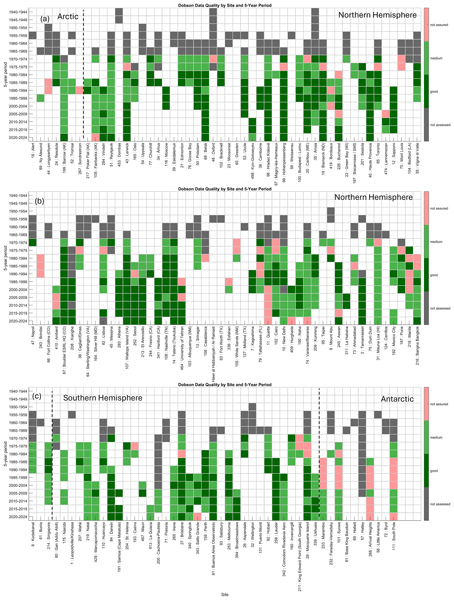
My first comment is a purely pragmatic one but is crucial. Many readers will only look at figures 6 to 11, which together form the main result of the manuscript. These figures need to make much more obvious that the quality criteria have been tuned separately for each network. This needs to be made clear in the caption of each figure and also the heading for each plot. The captions at the moment say "Same as … " but this is not actually correct.
Secondly, in general the text needs to include more explanation. Several points need more explicit treatment, and some details are skipped over. (I felt when reading the manuscript that the authors seemed to be in too much of a rush to get to the results).
The whole approach relies on assumptions which are never clearly stated. Satellite total ozone datasets have been extensively validated with ground observations and are frequently reprocessed with corrections which may be latitude or zenith angle dependent. They are also extensively compared with each other. At times though the discussion here implies that satellite observations can serve as independent reference data for ground measurements. Presumably the assumption is along the lines that departures from the general pattern of relation between stations and a given instrument indicate a problem with the station, but changes in the general pattern indicate a problem with the satellite? (As is evident in Figure 2 for example). It is clear from figures such as Figure 2 and Figure A1 that the satellites and reanalyses only agree with each other to within a broad band of roughly plus or minus 2%. This must put a limit on your approach.
The value of reanalysis data also is not made out (other than just convenience). The authors need to explain what is the benefit of reanalysis when the satellite overpasses are available from the satellites that have been assimilated.
I am especially unconvinced about the validity of using reanalysis prior to reliable satellite total ozone data. The onus is on the authors to explain why this is valid.
Many of the plots are too cluttered and it is difficult to discern a clear message from them (Figures 1 and 2 in particular are very cluttered and figure 5 could be improved).
The details of the quality tests are referred to but never explained systematically. In particular there is only scattered comments about what the tests are really looking for and how they are assessed (eg lines 88-89). Taking for example, the amplitude of the seasonal component of the difference, I would expect that a given instrument type at a certain latitude compared to a given satellite instrument would have an expected seasonal cycle of differences due to differences in the respective retrievals. You need to explain clearly how you then turn this into a quality check. I would suggest that, at least in the supplement, you plot an example of each of these tests to help the reader understand what their purpose is.
Similarly the method of combining all the satellite instruments together is not explained.
I appreciate that the current work is seen as an update to the older Fioletov papers but even so it needs to be reasonably self-contained and the reader shouldn't have to read the earlier work to understand the details of your approach.
(I am also mildly curious about the fact that no Chinese satellite total ozone datasets have been included?)
Line 26 "global monitoring" – perhaps "systematic" is more the point you're trying to make, rather than "global"? The first sites were distributed in different places around the world, and arguably we still don't have a "global" network.
Lines 41-43 I found this sentence confusing, who is "they"? Do you mean users of the data or operators of the ground sites?
Line 67 "reference network" needs defining – why exactly do you call Brewers "reference" but not Pandoras?
Line 69 "excellent spatial coverage and redundancy" – I can see a lot of white space in the lower panel of figure 1. How do you know that the spatial coverage and redundancy is sufficient outside of western Europe?
Line 78 "networks have expanded or emerged" - Dobsons and Brewers have decreased though.
Lines 78-79 This sentence doesn't make sense to me – how can the networks "offer a more comprehensive" evaluation of themselves?
Lines 103-104 This sentence seems over-stated. "Quality assured" and "traceable" have specific meanings in measurement which don't apply here.
Figure 1 – This figure is much too cluttered and I would say needs a complete redesign. It's very hard to see anything clearly or draw any sort of message from it. I leave this to the authors, but perhaps one suggestion would be to include six panels for the six instrument types.
Line 130 Why do you say "one of "? What would beat it?
Line 132 I suggest adding some words to this sentence making clearer that the stations are frequently calibrated by the regional standard instruments and not necessarily the world standard. The later wording in lines 141-142 is about Brewers.
Line 152-154 It's great that you found this problem and it was able to be corrected.
Lines 155-156 This paragraph reads a little bit strangely to me. It starts talking about UV/Vis in general but then some descriptions of the SAOZ specifically looks like it has been pasted in which is not totally relevant. For example, the abbreviation "CDP" isn't used again .
Line 169 Is this figure for SAOZ specifically? I believe the SAOZ instrument has changed over the years (mini-SAOZ).
Lines 177-178 "As expected" – is the implication then that instruments measuring in the UV are better?
Lines 156, 171, 185 What is the message you are wanting to convey by listing out the different species able to be measured? Is it that only the Dobson and Brewer were specifically designed to measure ozone? Does the order of the lists matter, meaning does it relate to the priority of the design?
Line 189 Where does the 1% figure come from?
Lines 190-191 "Upcoming versions … will address" - it would be more factual to say "are planned to " rather than "will", or "planned upcoming versions" or words to that effect – this all might never happen.
Lines 193-201 You need to give details of the overpass criteria that you've used. Are they consistent for all of these numerous instruments? You don't say anything here about drifts or about changes in crossing times.
Lines 212-213 I can't understand what this sentence means. It doesn't sound like the ozone value can be considered in any way reliable.
Lines 221-222 Why is this relevant?
Lines 225 How is the bias correction done, are the satellite values corrected to match ground observations?
Lines 226-227 Again, this is difficult to make sense of, but it sounds like the pre-satellite ozone values shouldn't be used in the way you're using them?
Lines 232-235 If the satellite data is corrected in this way, can it still be used to assess ground data? In the pre-1979 era the Dobson network was very sparse in many parts of the world.
Lines 243-244 Are you using daily averages for all ground-based data? (It seems to say so a few lines later but it would be clearer to state it here.) Did you consider finer temporal resolutions where it was available?
Line 249 This seems an important point in your analysis but it's rushed over. From what you're saying, the percentiles used later on are calculated with bad data already excluded? Doesn't this affect the use you make of the percentiles later on? (For example, being outside of the 90th percentile range is not so worrying if the 90th percentile is based on only good data). This should be explained. How did you identify the "low quality" data at this stage?
Lines 246-250 You've defined the daily difference but none of the other statistics. It's not sufficient to refer back to Fioletov et al. (1999).
Line 261 Define 'median difference' – do you average each station for a year and then take the median of all the different stations? Or is it the median of all station days? Or something else?
Line 269 Again, interquartile range of what exactly? Stations' daily differences?
Lines 272-274 This seems like an important point but it is skipped over and hard to follow.
Figure 2 – I find the figure much too cluttered. What is the message here? The overall agreement seems very good when completely averaged out but if the satellites have been reprocessed to match the ground networks and each other it's not so surprising.
Line 283-285 Doesn't it call into question the appropriateness of using reanalysis before the modern satellites were operational?
Lines 286-296 A lot of this repeats what has already been said earlier (lines 175-184).
Lines 304-306 Again, some of the different tests are listed ("such as … ") but none of them are ever concretely defined, or their purpose explained.
Lines 338-345 This section is very good but I would like to see it expanded and some plots be included to illustrate what the tests are showing.
Line 356 I can't see that the threshold criteria were defined in section 3.2.
Line 370 "models" – what do you mean here by "model"?
Lines 388-391 When you're counting up these issues, do you count "satellites" as just one, or is each specific sensor counted?
Lines 401-403 It seems to me using NASA AVDC is a great convenience but it does leave you at their mercy if they haven't included a site or have the wrong position for it (as you mention again in line 516). Did you ask them for the missing sites? "Reprocessing" is not the right word here, you would only be extracting overpass values from gridded data.
Figure 5 I can't say I like this figure very much at all. What most stands out to the eye is the solid bar. The different rows are too hard to compare. I suggest a redesign.
Line 424 "trace" – I don't know what you mean by "trace" here? Do you mean just "date", or do you need to uncover them somehow?
Line 426 IGY not IPY and 1957-1958.
Line 439 I don't think you really mean "assured" here. Quality Assurance has a definition. GAW has a Quality Assurance system, eg Quality Assurance
Line 440 What is the advantage of using five year bins?
Line 458 Do you mean "models" here, rather than "reanalyses"?
Line 483 "stronger" should be "greater" or just "larger"
Figure 8 Why don't the stations "SIN", "NAT', "BBN" and "HBT" have actual names? Are these Eubrewnet identifiers? You should give the place-name as well to help the reader.
Figure 8 caption – you can't say "same as" because the criteria for green is different.
Lines 505-511 The discussion repeats what has already been said previously, but I think the more important thing is that the figures need to make clear that the criteria for each network are different, for someone who only looks at the figures and doesn't read all the text. The captions needs to make this explicit.
Line 516 I hope you checked the others. It's disappointing that the mistakes were there but good that you found them.
Lines 518-519 I don't follow the logic of the sentence. Newer sites have not been included in AVDC. Isn't the problem that you are relying on an overpass service that (I believe) isn't being maintained anymore. It's not an issue of satellites per se.
Figure C1 I can't see any the circles or crosses other than in the first panel? It is hard to take a clear message from this figure.
Technical corrections
Line 129 Insert "The" before "Dobson network"
Line 134 Insert "the" before "1970s".
Line 136 Insert "the" before "Brewer"
Line 175 "since many years" – please reword
Line 230 Insert "a" before Kalman
Line 264 Reword "have been found suffering from"
Line 283 "glitches" – please change to a different word, perhaps "discontinuities"
Line 286 – "spectra" should be "spectral"
Line 311 "but not included in this work" shouldn't be in brackets
Line 324 Delete "were" before "changed"
Line 437 Insert "the" before "Dark green"
Line 438 Insert "a" before "Red".
Line 550 "decent" is not the right word here
Citation: https://doi.org/10.5194/egusphere-2026-2009-RC2 - AC2: 'Reply on RC2', Xiaoyi Zhao, 07 Aug 2026
Peer review completion
Journal article(s) based on this preprint
Data sets
NASA/GFSC total ozone satellite datasets NASA https://avdc.gsfc.nasa.gov/pub/data/satellite/
Brewer, Dobson, and Filter total ozone records WOUDC/ECCC https://woudc.org/
FTIR and UVVIS records NDACC https://www-air.larc.nasa.gov/missions/ndacc/data.html
Brewer total ozone records EUBrewnet https://eubrewnet.aemet.es/eubrewnet
Pandora total ozone records PGN https://www.pandonia-global-network.org/home/documents/pgn-data/
TROPOMI overpass total ozone files ECCC https://hpfx.collab.science.gc.ca/~deg001/tropomi_ovp/
ERA5 reanalysis total ozone ECMWF https://cds.climate.copernicus.eu/datasets/reanalysis-era5-single-levels?tab=overview
MERRA-2 reanalysis total ozone Global Modeling and Assimilation Office (GMAO) https://disc.gsfc.nasa.gov/datasets?project=MERRA-2
JRA3Q reanalysis total ozone JMA https://gdex.ucar.edu/datasets/d640000/dataaccess/#
MSR2 reanalysis total ozone KNMI https://www.temis.nl/protocols/o3field/o3field_msr2.php
Viewed
| HTML | XML | Total | BibTeX | EndNote | |
|---|---|---|---|---|---|
| 526 | 299 | 62 | 887 | 84 | 79 |
- HTML: 526
- PDF: 299
- XML: 62
- Total: 887
- BibTeX: 84
- EndNote: 79
Viewed (geographical distribution)
| Country | # | Views | % |
|---|
| Total: | 0 |
| HTML: | 0 |
| PDF: | 0 |
| XML: | 0 |
- 1

Vitali Fioletov
Irina Petropavlovskikh
Voltaire Velazco
Alberto Redondas
Anna Solomatnikova
Corinne Vigouroux
Kimberly Strong
Michel Van Roozendael
Andrea Pazmino
Thomas F. Hanisco
Alexander Cede
Martin Tiefengraber
Gordon Labow
Masatomo Fujiwara
Ronald van der A
Debora Griffin
Chris McLinden
Tom Kralidis
Wolfgang Steinbrecht
Sum Chi Lee
The requested preprint has a corresponding peer-reviewed final revised paper. You are encouraged to refer to the final revised version.
- Preprint
(5669 KB) - Metadata XML
The paper is of high relevance for the scope of ACP. It assesses the quality of the largest ground-based total column ozone observation networks in a time-dependent manner and allows to identify problematic stations and times. It also provides intercomparisons between the ground-based records and the major satellite and re-analysis products.
The paper is based on a sound methodology and well written. I recommend it for publication after minor revisions.
specific comments:
- l. 37-39: differences to what, re-analysis? what is the internal consistency for Dobsons?
- l. 65/191: you might also want to put this into context with the upcoming activities with the BTS array spectrometers with WMO / SAG ozone mandating some evaluation of its capacity as potential 3rd generation ozone reference instrument as an information to the reader. But as there is no network associated to it (at least for now) I leave it to you if you to decide if you think such a statement would be sensible.
- l. 80-81: what do you exactly mean by "assimilation-driven shifts in the reanalysis datasets"? Some clarification and also the mention which datasets are (not) assimilated in which re-analyses will help to better understand not only this sentence but the whole paper.
- l. 91: similar to the above comment. Can you explain what you mean by time-dependent shifts in data assimilation
- l. 113: "from their entire 85-year records" -> as you mention in the introduction some sites started measuring in the 1920ies already, there are active stations with > 85 years of data.
- Fig 1. Please specify in the caption what the size of the circle means. Without this information the figure is not clear to me. Additionally a small cosmetic comment: the figure you provide seems to have lost its aspect ratio in the sense that the "circles" are actually ellipses (higher than wide)
- l.125-126: "it employs a double monochromator and optical wedge system to provide high measurement precision" --> you might also want mention the long optical path within the instrument which is an advantage in terms of stray light suppression
- l. 125: "e.g. zenith sky" --> also mention Umkehr
- l. 129: I would argue that "IGY" would be a more adequate and widely used abbreviation for the International Geophysical Year.
- l. 129: "Dobson network" --> "The Dobson network"
- l. 131: Mention that D083 is itself calibrated using Langley plots under the excellent atmospheric conditions at Mauna Loa
- l. 125-133: please specify which ozone cross-sections and ozone effective temperatures were used in the retrieval of the data in the actual paper. This is especially relevant for Dobson spectrophotometers where the often-used Bass and Paur cross-sections with constant temperature are known to introduce a artificial seasonal cycle (and an offset at polar sites) which may interfere with your seasonality analysis. Please also make a statement in your analysis how this change would affect it.
- l. 136-137: why do you capitalize "World" and "Regional" but not "calibration centres". This looks strange to me.
- l. 167-168: I do not understand why using radiative transfer for the airmass is a "cost" in itself. In my eyes, it would rather be the input data to the model that can introduce uncertainty, but I would argue that you have these assumptions almost everywhere. Dobsons and Brewers calculate an airmass based on geometrical considerations and atmospheric profiles.
- l. 206: please make clear from the beginning that (almost) no ground-based data is assimilated in any of the re-analyses, so that these can be considered as independent validation data for the ground-based observations, except for MSR2 before 1979 (and to some degree maybe also afterwards due to the correction you mention)
- l. 266-269, Fig. 2: A comment on the almost zero pre-satellite bias of MSR2 with Dobson assimilated might be insightful (to guide the reader in first place). If additionally you can think of a way to assess whether this is only due to quite local tearing of the model towards the assimilated observations which are also used for verification or by how much this is a real general improvement of the model quality (i.e. if there are non-assimilated ground-based observations for verification, e.g. filter ozonometer), this would be a very interesting finding.
- Fig. 3: please make more clear that in panel b) you are showing the std over all stations' annual means (at least that is what I understood/guessed from your plot).
- l. 304-306. This is almost the same sentence as at the beginning of section 2.4. Please rephrase and/or consider avoiding duplication.
- l. 330-331: this is a bit like comparing peers to apples and might advantage the dataset with the shortest records, because satellite and re-analysis quality could be expected to be best in the more recent years. Could you please indicate the same values for a coincident time period of all instruments as well?
- l. 337: From l. 228-235 I had understood that MSR2 just assimilated Dobson in the pre-satellite era, so I am confused with the statement "This is because MSR2 assimilated the Brewer and Dobson observations from some sites" made here. Please clarify this and the reason for the better agreement.
- Fig C1: The fact of showing lines in this graph is confusing as it suggests that the different datasets are somehow related in a series. Why not showing this as stacked boxplots or something the like?
l. 369-381: you tend to use "will" here, but I assume you are rather speculating on what "would" happen if...
- l.389: I don't understand your condition 2). Can you describe it a little more, so that the reader is not obliged to check Fioletov et al. just to understand the main working idea of your method. Finally it is your main classification method and would deserve a little more description (although it is similar to Fioletov et al.)
- l. 399-401: the parameters given in the parentheses seem more important to me than to be given in form of such a sidenote. Either move to some methodology section or a table.
- Fig. 6/7: why is Davos not mentioned as a continuation of the Arosa time series? The operators and PI's of this site are presenting this time series as one with a generic Arosa-Davos station and there are ongoing homogenisation efforts for an improuve merge of Arosa and Davos. Stübi et al. 2017 and 2021 analysed the re-location and concluded the effect is < 0.5%.
- l. 501-502: reformulate the part related to FTIR in the sense that it becomes clear that you have primarily used the reprocessed time series in the present work. Are the newer data (after 2023) processed by the individual institutes again?
-l. 523-524: "..., which their PI might lack..." sounds strange and not really causal to me. Please re-formulate
-l. 549: "The sites host ..." please reformulate this sentence/the tense of it.