
the Creative Commons Attribution 4.0 License.
the Creative Commons Attribution 4.0 License.
 | 26 Jan 2026
Cloud Fields and Aerosol Classification with Lidar using Advanced AI Approach
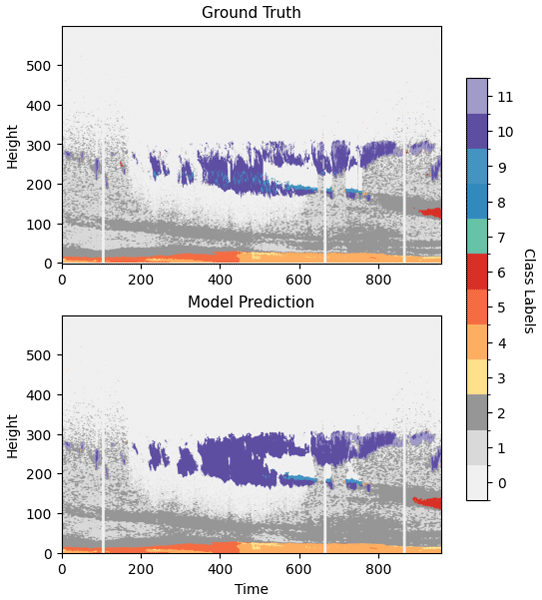
Abstract. Understanding the vertical distribution of aerosol and clouds is critical for climate modeling, weather forecasting, and air quality monitoring. Lidar observations are central to profiling atmospheric composition, yet signal attenuation in optically thick layers limits the effective retrieval of some important properties above those layers. More complex measurement approaches, using a combination of Lidar and cloud radar systems, can be taken to support more inclusive and accurate inference. In this study, we develop a deep learning framework to address this trade-off and gap in cost of data acquisition by enabling full-column aerosol and cloud classification using only standard lidar inputs. The approach is based on a U-Net architecture trained to predict combined aerosol and cloud types from vertical profiles of backscatter and depolarization. Classification targets integrate established aerosol typing from PollyXT with cloud and precipitation categorization from Cloudnet, facilitating a unified scheme. The model achieves high precision, recall and F1-scores above 95 %. By evaluating numerous complex case studies, we establish the model's ability to exploit information embedded in the lidar signal below attenuating layers, including structural and contextual features, to infer atmospheric conditions at higher altitudes, offering a robust AI-based enhancement to lidar-based atmospheric profiling and target classification. The application of AI in this context closes the gap between the need for vertical cloud maps and the sparse availability of Cloudnet.
-
Notice on discussion status
The requested preprint has a corresponding peer-reviewed final revised paper. You are encouraged to refer to the final revised version.
-
Preprint
(5301 KB)
-
The requested preprint has a corresponding peer-reviewed final revised paper. You are encouraged to refer to the final revised version.
- Preprint
(5301 KB) - Metadata XML
- BibTeX
- EndNote
- Final revised paper


Journal article(s) based on this preprint
Interactive discussion
Status: closed
-
RC1: 'Comment on egusphere-2025-5215', Anonymous Referee #3, 16 Feb 2026
-
AC1: 'Reply on RC1', Yoni Peleg, 07 May 2026
We thank the reviewer for pointing out the relevant work by A. Fuller et al. (2025), Using Multitask Machine Learning to Type Clouds and Aerosols from Space-Based Photon-Counting Lidar Measurements. Indeed, we were not aware of the aforementioned paper during the initial submission of our work. We have added a citation and a discussion of this paper to our introduction/literature review.
While both studies utilize U-Net-based deep learning architectures to enhance Lidar retrievals, our approach differs fundamentally in its training objective and the physical capabilities of the resulting model. A. Fuller et al train their model using CATS L2O operational products, which are derived solely from CATS Lidar measurements. Consequently, their model, while improving resolution and detection of tenuous layers, remains constrained by the physical limitations of Lidar signal attenuation as it cannot be trained to classify atmospheric features where the Lidar signal is fully extinguished. In contrast, our model is trained on a single consistent labeling schema aligned with Cloudnet and PollyXT standards, which combine lidar and radar data. Because the radar penetrates optically thick layers that fully attenuate the Lidar signal, our ground truth contains "invisible" information (from the Lidar's perspective). This allows our model to learn contextual correlations and infer cloud and precipitation properties above the Lidar attenuation limit, effectively mimicking a Lidar-Radar synergy using only Lidar inputs. Thus, we have demonstrated that Cloudnet-like classification can be approximated using only a single lidar system. This represents a methodological and operational advancement beyond previous approaches. Revisions were added to the introduction and discussion sections.
Citation: https://doi.org/10.5194/egusphere-2025-5215-AC1
-
AC1: 'Reply on RC1', Yoni Peleg, 07 May 2026
-
RC2: 'Comment on egusphere-2025-5215', Anonymous Referee #1, 05 Apr 2026
The comment was uploaded in the form of a supplement: https://egusphere.copernicus.org/preprints/2026/egusphere-2025-5215/egusphere-2025-5215-RC2-supplement.pdf
- AC2: 'Reply on RC2', Yoni Peleg, 12 May 2026
Peer review completion


Interactive discussion
Status: closed
-
RC1: 'Comment on egusphere-2025-5215', Anonymous Referee #3, 16 Feb 2026
The manuscript is well written and provides application of machine learning to up-looking ground-based lidar.
The authors should also look at the very highly relevant publication: Fuller et al., (2025) "Using multitask machine learning to type clouds and aerosols from space-based photon-counting lidar measurements," Remote Sensing, doi: 10.3390/rs17162787. This recent publication is highly relevant and seemingly very similar to the submitted manuscript (i.e., using U-Net to perform cloud/aerosol sub-typing). Given the August 2025 publication date, the authors probably had not seen this paper before submitting theirs, but they should at least be aware of this publication as it does take ICESat-2 analysis beyond just the binary cloud-aerosol discrimination (a shortcoming specifically noted in lines 72-73).
Citation: https://doi.org/10.5194/egusphere-2025-5215-RC1 -
AC1: 'Reply on RC1', Yoni Peleg, 07 May 2026
We thank the reviewer for pointing out the relevant work by A. Fuller et al. (2025), Using Multitask Machine Learning to Type Clouds and Aerosols from Space-Based Photon-Counting Lidar Measurements. Indeed, we were not aware of the aforementioned paper during the initial submission of our work. We have added a citation and a discussion of this paper to our introduction/literature review.
While both studies utilize U-Net-based deep learning architectures to enhance Lidar retrievals, our approach differs fundamentally in its training objective and the physical capabilities of the resulting model. A. Fuller et al train their model using CATS L2O operational products, which are derived solely from CATS Lidar measurements. Consequently, their model, while improving resolution and detection of tenuous layers, remains constrained by the physical limitations of Lidar signal attenuation as it cannot be trained to classify atmospheric features where the Lidar signal is fully extinguished. In contrast, our model is trained on a single consistent labeling schema aligned with Cloudnet and PollyXT standards, which combine lidar and radar data. Because the radar penetrates optically thick layers that fully attenuate the Lidar signal, our ground truth contains "invisible" information (from the Lidar's perspective). This allows our model to learn contextual correlations and infer cloud and precipitation properties above the Lidar attenuation limit, effectively mimicking a Lidar-Radar synergy using only Lidar inputs. Thus, we have demonstrated that Cloudnet-like classification can be approximated using only a single lidar system. This represents a methodological and operational advancement beyond previous approaches. Revisions were added to the introduction and discussion sections.
Citation: https://doi.org/10.5194/egusphere-2025-5215-AC1
-
AC1: 'Reply on RC1', Yoni Peleg, 07 May 2026
-
RC2: 'Comment on egusphere-2025-5215', Anonymous Referee #1, 05 Apr 2026
The comment was uploaded in the form of a supplement: https://egusphere.copernicus.org/preprints/2026/egusphere-2025-5215/egusphere-2025-5215-RC2-supplement.pdf
- AC2: 'Reply on RC2', Yoni Peleg, 12 May 2026
Peer review completion
Journal article(s) based on this preprint
Model code and software
YakhiniGroup/cloud-fields-identification: cloud-fields-identification Yonatan Peleg https://doi.org/10.5281/zenodo.17422969
Viewed
| HTML | XML | Total | BibTeX | EndNote | |
|---|---|---|---|---|---|
| 1,804 | 917 | 116 | 2,837 | 106 | 203 |
- HTML: 1,804
- PDF: 917
- XML: 116
- Total: 2,837
- BibTeX: 106
- EndNote: 203
Viewed (geographical distribution)
| Country | # | Views | % |
|---|
| Total: | 0 |
| HTML: | 0 |
| PDF: | 0 |
| XML: | 0 |
- 1
Yonatan Peleg

Lior Zeida-Cohen
Imri Tzror
Johannes Bühl
Albert Ansmann
Alexandra Chudnovsky
Zohar Yakhini
The requested preprint has a corresponding peer-reviewed final revised paper. You are encouraged to refer to the final revised version.
- Preprint
(5301 KB) - Metadata XML
The manuscript is well written and provides application of machine learning to up-looking ground-based lidar.
The authors should also look at the very highly relevant publication: Fuller et al., (2025) "Using multitask machine learning to type clouds and aerosols from space-based photon-counting lidar measurements," Remote Sensing, doi: 10.3390/rs17162787. This recent publication is highly relevant and seemingly very similar to the submitted manuscript (i.e., using U-Net to perform cloud/aerosol sub-typing). Given the August 2025 publication date, the authors probably had not seen this paper before submitting theirs, but they should at least be aware of this publication as it does take ICESat-2 analysis beyond just the binary cloud-aerosol discrimination (a shortcoming specifically noted in lines 72-73).